Sentinel-3 is an European Earth Observation satellite mission developed to support Copernicus ocean, land, atmospheric, emergency, security and cryospheric applications.
The main objective of the Sentinel-3 mission is to measure sea surface topography, sea and land surface temperature, and ocean and land surface colour with high accuracy and reliability to support ocean forecasting systems, environmental monitoring and climate monitoring. The mission definition is driven by the need for continuity in provision of ERS, ENVISAT and SPOT vegetation data, with improvements in instrument performance and coverage.
The Sentinel-3 mission is jointly operated by ESA and EUMETSAT to deliver operational ocean and land observation services.
The spacecraft carries four main instruments:
- OLCI: Ocean and Land Colour Instrument
- SLSTR: Sea and Land Surface Temperature Instrument
- SRAL: SAR Radar Altimeter
- MWR: Microwave Radiometer.
These are complemented by three instruments for Precise Orbit Determination (POD):
- DORIS: a Doppler Orbit Radio positioning system
- GNSS: a GPS receiver, providing precise orbit determination and tracking multiple satellites simultaneously
- LRR: to accurately locate the satellite in orbit using a Laser Retro-Reflector system.
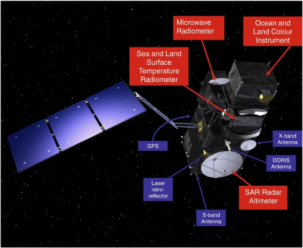
Figure 1: Sentinel-3 Satellite and Payloads (Credit: ESA)