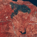
Wildfires have broken out across southern Europe as a heatwave grips the region. This animation created using images from the Copernicus Sentinel-2 satellites show the live blaze and aftermath of wildfires that devastated an area about 35 km northeast of Athens, Greece, in mid-August.
The images from 14 August show the blaze and billowing smoke, which extends far south pushed by strong winds.
Vegetation appears red in the false-colour images from 19 August, and burn scars covering an area of over 2900 hectares appear black.
Satellites like Sentinel-2 allow these crisis situations to be carefully monitored and mapped, at both regional and global scales. Sentinel-2 imagery combined with data from Copernicus contributing missions are being used to produce maps of this recent fire through the Copernicus Emergency Management Service for damage assessment.
