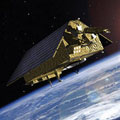
ESA and Airbus Defence and Space today signed a €177 million contract to develop the Jason-CS / Sentinel-6A satellite mission for Europe's Copernicus programme.
The mission will use a radar altimeter to observe changes in sea-surface topography with centimetre precision, providing insights into global sea levels, the speed and direction of ocean currents and ocean heat storage.
These continuous measurements are vital for modelling the oceans and predicting rises in sea levels. With the signing of today's contract, the satellite is foreseen to be launched in 2020.
Jason-CS / Sentinel-6 will ensure the continuation of ocean surface topography measurements from its Jason-3 predecessor, planned for launch this summer.
