
Overview
The Extended Timing Annotation Dataset (ETAD) for Copernicus Sentinel-1 is a new auxiliary product developed by ESA (with DLR as contractor), providing users with corrections to improve geometric accuracy of Sentinel-1 SLC images to centimetric levels. The product contains analysis-ready layers for removing the atmospheric path delays, the solid Earth tidal deformation, and the Sentinel-1 system specific effects related to the IPF SAR processor.
The processor is currently being integrated in the ground segment and ETAD products should be available to the public in the second half of 2023.
Description
Precise geolocation for geodetic measurements in the centimetre accuracy range with SAR instruments has been demonstrated in the past years and yielded an emerging field of applications. This precision is not achieved out-of-the-box when using the orbit, the speed of light and the satellite velocity alone to transform the annotated timing parameters of a SAR product into geo-referenced positions.
Rather, the Radar pulses transmitted and received by SAR satellites like Sentinel-1 are subject to signal propagation delay variations when passing through different layers of Earth's atmosphere, i.e., troposphere and ionosphere. These delays depend on the actual atmospheric conditions at a certain time and location and the specific geometry of the SAR acquisition.
Also, objects measured on the ground are not in a stable position with regards to absolute geo-coordinates. The dominant displacement effects are caused by the Solid-Earth Tides (SET) of the Sun and the Moon, which induce temporal variations of the location with respect to a reference coordinate frame.
Additionally, approximations are used in the SAR image formation and product time annotation process, which do not fully take into account the movement of the instrument during the signal travel time, the squint angle/Doppler and topographic height variations during the TOPS observations.
All the geo-physical effects can be calculated based on the determined orbits and annotated timing information in the SAR product by evaluating tropospheric numerical weather prediction (NWP) models, ionospheric Total Electron Content (TEC) data and geodynamic models. The errors induced by the SAR processing approximations can be accurately estimated by analysing the SAR timeline and by the Doppler and FM-rate parameters based on an accurate Digital Elevation Model (DEM).
| Before ETAD correction | After ETAD correction | |||
| Range | Azimuth | Range | Azimuth | |
| TOPS IW | 7.0* | 7.0* | 0.2 | 0.1 |
| Stripmap | 2.5* | 2.5* | 0.2 | 0.1 |
Data Set Specifications
Creating a data set to correct for the described effects is the task of the SETAP (Sentinel-1 Extended Timing Annotation Processor) developed and implemented by DLR under ESA contract. With the output of the processor, i.e. the ETAD product that contains the correction data set, any user may thus achieve precise geolocation from a Sentinel-1 standard SLC product.
The ETAD product provides grids to the user, which specify the azimuth and range timing corrections for all the different effects, and which are applicable to each burst of a TOPS and Stripmap (SM) data take. Additionally, the sums of the corrections and mapping grids to translate timing information to geographic coordinates are provided. The individual grids are packed in a container file in NetCDF format supplemented with annotation parameters and XML annotation components.
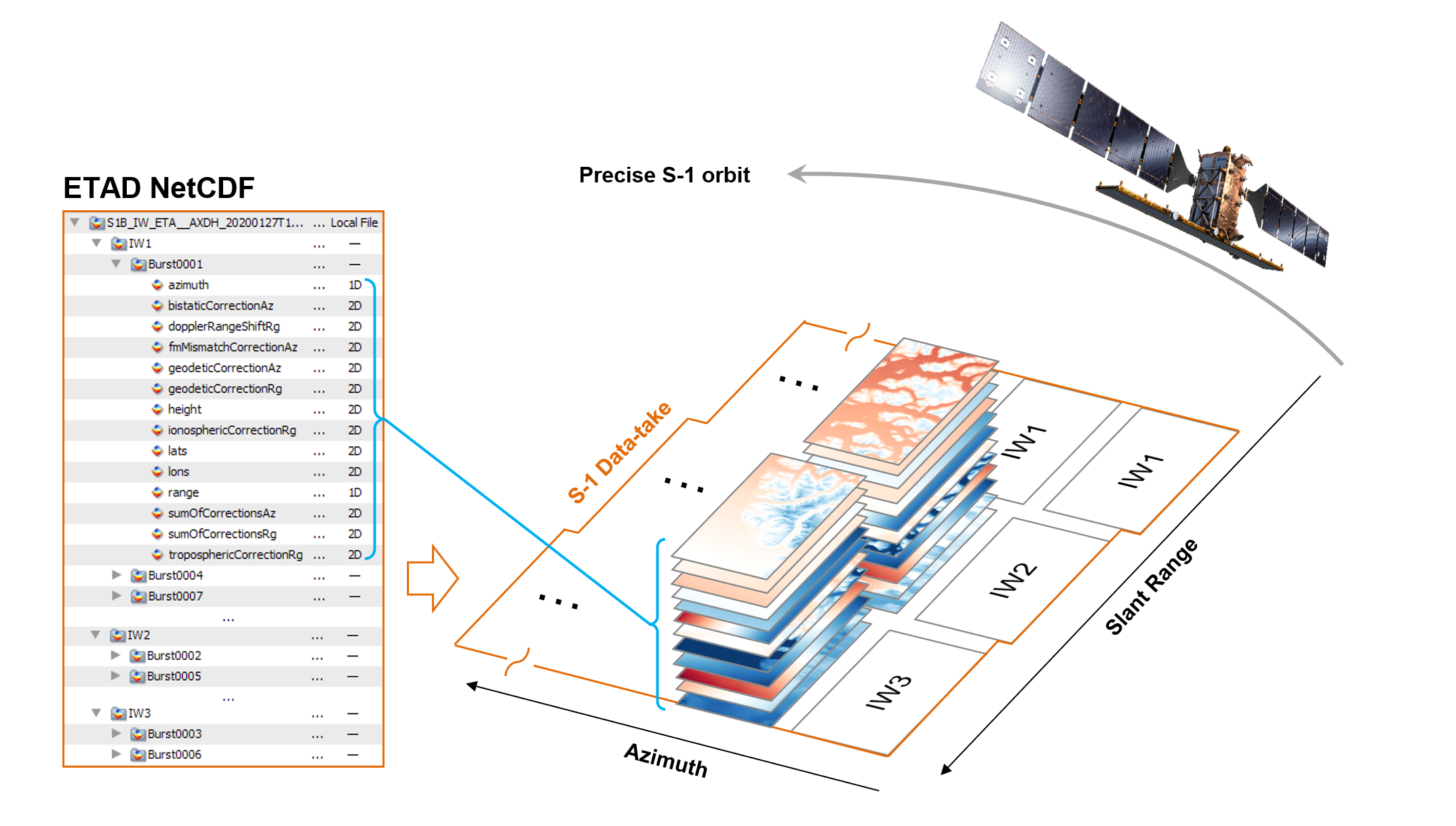
The product content, its rationale as well as the application to the SAR products, is detailed in the Product Definition Document. In the Product Format Specification document, only the format, the structure and the naming of the provided data files are specified.
Processing Level
Ancillary
How to use this data
With the Sentinel-1 ETAD product that contains the correction data set, any user may thus achieve precise geo-location from a Sentinel-1 standard SLC product. For details and examples on applications see the dedicated ETAD Product Definition Document.
A Python API is available to access the ETAD corrections for the Sentinel-1 SLC product.
Resources
- Sentinel-1 Extended Timing Annotation (ETAD) - ATBD
- Sentinel-1 Extended Timing Annotation (ETAD) - Product Definition Document
- Sentinel-1 Extended Timing Annotation (ETAD) - Product Specification Document
- C. Gisinger et al., "In-Depth Verification of Sentinel-1 and TerraSAR-X Geolocation Accuracy Using the Australian Corner Reflector Array," in IEEE Transactions on Geoscience and Remote Sensing, vol. 59, no. 2, pp. 1154-1181, Feb. 2021, doi: 10.1109/TGRS.2019.2961248.