To promote full utilisation of SENTINEL data, increased scientific research, growth in EO markets and job creation, SENTINEL data is provided on an open and free basis by ESA and the European Commission based on the following principles:
- Anyone can access acquired SENTINEL data. In particular, no distinction is made between public, commercial and scientific uses, or between European or non-European users.
- Licenses for the use of SENTINEL data are available free of charge.
- SENTINEL data will be made available to users via 'generic' online access, free of charge, subject to a user registration process and acceptance of generic terms and conditions.
- Additional access modes and delivery of additional products will be tailored to specific user needs and will be subject to tailored conditions.
- In the event that security restrictions apply, affecting the availability or timeliness of SENTINEL data, specific operational procedures will be activated.
Large scale on-line distribution of the SENTINEL data will be possible within the technical limitations of the system (in particular the dissemination network) and depends on operational funding levels.
Open and free access to the data will maximise the beneficial utilisation of SENTINEL data for the widest range of applications and intends to stimulate the uptake of information based on Earth Observation data for end users.
All SENTINEL-1 SAR data acquired are systematically processed to create predefined product types and are available globally, regionally and locally, within a defined timescale.
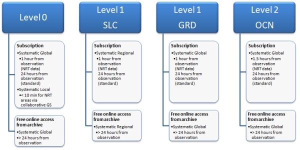
Global products will be systematically generated for all acquired data. They include Level-0, detected Level-1 and Level-2 ocean products. These products are made available within 1 hour of observation over NRT areas with a subscription and, in every case, within 24 hours of observation.
Regional products are systematically generated for a subset of the total acquired data, over well-defined regions or areas. Level-1 SLC products are made available within 1 hour of observation over specific NRT areas and systematically over specified areas within 24 hours of observation. The systematic processing approach allows the systematic generation of a pre-defined set of Level-1 products after acquisition (either in NRT or within 24 hours), with no ordering required for each product to be generated.
For critical GMES and national services requiring data in quasi real-time, notably maritime surveillance, data are transmitted by the satellite in real-time for reception by local collaborative ground stations supporting these services. This requires that SENTINEL-1 is inside the coverage of these collaborative ground stations.

Figure 1: Operational Product Availability for Each Level
In addition to systematic and routine production, rush processing with high priority at the ground receiving stations, will support emergency/security related observation requests. These observations will be minimised to within the strict necessary duration to avoid overriding the pre-defined observation scenario.