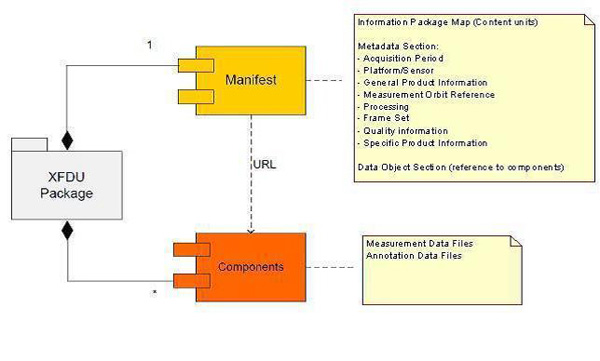
The OLCI data format follows the format defined for each Sentinel-3 product in the PDGS product specification and is based on SENTINEL-SAFE.
SENTINEL-SAFE is based on the XML Formatted Data Units (XFDU) developed by the Consultative Committee for Space Data Systems (CCSDS). SENTINEL-SAFE is a profile of XFDU, and it restricts the XFDU specifications for specific utilisation in the EO domain, providing semantics in the same domain to improve interoperability between ground segment facilities.

Figure 2: XFDU package schema
Each product package includes:
- a manifest file containing a metadata section and a data object section
- measurement data files
- annotation data files, if defined
- for Level-0 only, representation data files (XML files describing the binary information).
Sentinel-3 user products are disseminated in Product Dissemination Units (PDU), in order to ease the online dissemination and data handling for the users. The PDU is a portion of data and is defined per product type.
| Level | Name of Product Package |
Main Content | Use | Latency | Estimated Size per half Orbit |
Product Dissemination Unit (PDU) |
| 0 | OL_0_EFR | Full Resolution ISPs | INTERNAL | NRT | 9.5GB | N/A |
| OL_0_CR0 | Calibration with no spectral relaxation | 502Mb | ||||
| OL_0_CR1 | Calibration with spectral relaxation | 240Mb | ||||
| 1 | OL_1_EFR | Full Resolution TOA Reflectance | NRT/NTC | 28.5GB | Frame 3 mn | |
| OL_1_ERR | Reduced Resolution TOA Reflectance | 2.3GB | Dump (full daylight orbit) | |||
| OL_1_RAC | Dark offset and gain coefficients from radiometric calibration | INTERNAL | NRT | 1Mb | N/A | |
| OL_1_SPC | Wavelength characterization from spectral calibration | 27Mb | ||||
| 2 | OL_2_WFR | Full Resolution Water and Atmosphere geophysical products | USER | NRT/NTC | 28.4GB | Frame 3 mn |
| OL_2_LFR | Full Resolution Land and atmosphere geophysical products | 8.8GB | ||||
| OL_2_WRR | Reduced Resolution Water and Atmosphere geophysical products | 2.4GB | Dump (full daylight orbit) |
- EFR Earth Observation Full Resolution
- ERR Earth Observation Reduced Resolution
- RAC Radiometric Calibration
- SPC Spectral Calibration
- WFR Water Full Resolution
- LFR Land Full Resolution
- WRR Water Reduced Resolution
- LRR Land Reduced Resolution