SENTINEL-2 products available for Users are listed in Tables 1 and 2.
| Type | Code | Description | Users | Production & Distribution |
| User Product | Level-1B | Top-Of-Atmosphere radiances in sensor geometry | Expert Users | Systematic generation and online distribution |
| Level-1C | Top-of-atmosphere reflectances in cartographic geometry | All Users | Systematic generation and online distribution | |
| Level-2A | Atmospherically corrected Surface Reflectances in cartographic geometry |
Additionally, the following pilot products are generated on-demand:
| Type | Code | Description | Users | Production & Distribution |
| Pilot Products | Level-2H | Harmonised Sentinel-2 + Landsat-8/9 surface reflectances in cartographic geometry | All Users | On-demand pilot productions |
| Level-2F | Fused Sentinel-2 + Landsat-8/9 surface reflectances in cartographic geometry |
The continuous acquisition of SENTINEL-2 image data in a given MSI mode is called a "datatake". The maximum length of an imaging datatake is 15,000 km (e.g. continuous observation from northern Russia to southern Africa). All products contain granules/tiles from a single datatake. A datatake is presented inside a product as a set of one or more datastrips (corresponding to acquisition segments downlinked to different ground stations).
The products are elementary granules of fixed size, within a single orbit. A granule is the minimum indivisible partition of a product (containing all possible spectral bands).
For Level-1B granules are small images in sensor geometry sensed by each of the twelve MSI detectors and are 23x25 Km2 large.
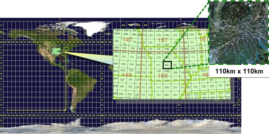
For Level-1C and Level-2A, the granules, also called tiles, are 110x110 km² ortho-images in UTM/WGS84 projection. Earth is subdivided on a predefined set of tiles, defined in UTM/WGS84 projection and using a 100 km step. However, each tile has a surface of 110x110 km² in order to provide large overlap with the neighbouring. The UTM (Universal Transverse Mercator) system divides the Earth's surface into 60 zones. Each UTM zone has a vertical width of 6° of longitude and horizontal width of 8° of latitude (see Figure 1).

Figure 1: Level-1C product tiling
Tiles can be fully or partially covered by image data. Partially covered tiles correspond to those at the edge or top/bottom of the Datastrip.
Download the Sentinel-2 tiling grid kml.