The Sentinel-2 Level-2H product provides harmonized Sentinel-2 and Landsat 8/9 orthorectified Surface Reflectance (Bottom-Of-Atmosphere: BOA), with sub-pixel multispectral and multitemporal registration accuracy. The harmonization process includes: geometric processing (stitching and registration to a common reference: GRI), common atmospheric processing, BRDF adjustment and SBAF adjustment.
The Sentinel-2 Level-2F product provides fused Sentinel-2 and Landsat 8/9 orthorectified Surface Reflectance (Bottom-Of-Atmosphere: BOA), with sub-pixel multispectral and multitemporal registration accuracy. The fusion includes the upscaling of L8/L9 data to S2 resolution (cf. Figure 1).
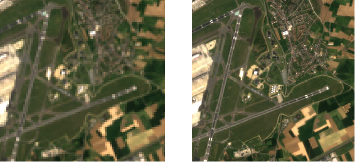
Figure 1 - L2H at 30m (left) and L2F at 10 m (right) based on Landsat-8 images
Figure below depicts the main processing steps of Sen2Like for generating the L2H and L2F starting from L1C. The Sen2Like processor is anyhow able to ingest also L2A.

Figure 2 - Level-2H and Level-2F processing chain
Additional details on theL2H/L2FProcessing Chain and relevant Results can be found on the following link (MDPI Paper).
The main characteristics of L2H and L2F products are listed in the following table.
|
Sentinel-2 L2H Product Characteristics |
||
|
Name |
Level-2H |
Level-2F |
|
High-level Description |
Harmonized Sentinel-2 and Landsat 8/9 Surface reflectances in cartographic geometry for 7 spectral bands. |
Fused Sentinel-2 and Landsat 8/9 Surface reflectances in cartographic geometry for 7 spectral bands. |
|
Algorithm used |
Sen2Like – Version 4.0 |
|
|
Data Characteristics |
|
|
|
Additional Layers |
|
|
| AC used | Sen2Cor or SMAC | |
|
DEM used |
||
|
Auxiliary Data used |
|
|
|
Quality Indicators |
|
|
|
Production & Distribution |
Ad-hoc generation and on-line distribution |
|
|
Data Volume |
Data Volume 800 MB (each 110x110 km2) |
|
|
Data Delivery |
N/A |
|
How to access this data
Products will be available via the on-demand Open-EO processing service in the coming weeks. In addition to the on-demand download services, users can directly run Sen2Like processor to generate their own L2H and L2F products.
Sen2Like processor is available on this GitHub page: https://github.com/senbox-org/sen2like
Resources
- Sentinel-2 Level-2H/L2F ATBD
- Sentinel-2 Level-2H/L2F Product Specifications Document
- Sentinel-2 Level-2H/L2F Product Definition Document
Tools
The Sentinel-2 Toolbox consists of a rich set of visualisation, analysis and processing tools for the exploitation of MSI data from the Sentinel-2 mission.
Data Citation Guidelines Collection 1
Users, who, in their research, use ESA Earth Observation data that have been assigned a DOI, are asked to use it when citing the data source in their publications:
Copernicus Sentinel-2 (processed by ESA), 2021, MSI Level-2H/F Harmonized/Fused Reflectance Product. Collection 1. European Space Agency. https://doi.org/10.57780/esa-4862e7e