The Meteosat Third Generation (MTG) ground segment allows all SENTINEL-4 data to be systematically acquired, processed and distributed.
It includes elements for monitoring and controlling the MTG satellites and for downloading, processing and disseminating data to users. It also has mechanisms for monitoring and controlling the quality of data products, as well as for data archiving.
The MTG ground segment is to be built-up over a number of years; initially handling the first MTG-I satellite and then expanding to include also the parallel operations of the first MTG-S satellite on which SENTINEL-4 flies.
The MTG ground segment is composed of a series of MTG specific elements plus a series of multi-mission elements that are common across several EUMETSAT missions.
The main MTG specific elements are:
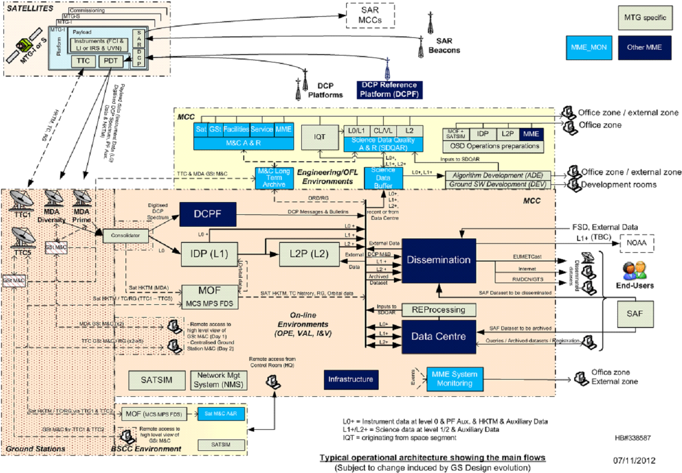
- The Ground Station Facilities (GSTF) which: 1) acquire the Ka band signal from the satellites that contain the payload data, including the SENTINEL-4 instrument data, and 2) acquire the satellite's housekeeping telemetry and transmit telecommands, tracking and ranging data on S-band. The Ka band receiving stations will be located at two sites separated by a distance of less than 200km where each site has one receiving antenna per operational MTG satellite. There will be a number of S-band antennas at various locations in Europe to perform the telemetry, tracking and commanding of the satellites.
- The Mission Operations Facility (MOF) that supports planning of the mission including each instrument, monitors the space segment, and performs the flight dynamics functions. In general MTG instrument planning, including SENTINEL-4, is based on orbital dynamics predictions calculated on ground which are translated into instrument observing events scheduled on-board the satellite.
- The Instrument Data Processing (IDP) that transforms, for each instrument, the received science and housekeeping telemetry into Level-1 data sets. For SENTINEL-4 the IDP produces Level-1B data, defined as fully geo-physically calibrated measurement data, that is a result of calibrating digital counts into radiances or irradiances, pixels into wavelengths and pixels into geophysical coordinates and viewing angles on the surface of the Earth.
- The Level-2 Processing (L2P) that transforms, for each instrument, the Level-1B data sets into Level-2 data sets. For SENTINEL-4 the L2P outputs consist of retrieved atmospheric trace gases (e.g. O3, NO2, SO2, HCHO) from the Level-1B radiances and irradiances.
- The Instrument Quality Tool (IQT) that is used, for each instrument, to verify instrument performance during on-ground testing and during the in-flight commissioning. For SENTINEL-4 the IQT is expected to perform radiometric performance tests, spectral performance tests and geometric (i.e. geolocation) tests.
The main MTG multi-mission elements are:
- The data centre element that provides a long-term repository of the archived data sets for all instruments, an interface that allows end-users to have access to data stored in the repository, and servers for the exchange of data with specific parties.
- The dissemination element that provides a series of mechanisms for the rapid delivery of generated data sets to various users. One of these mechanisms is EUMETCast which broadcasts uploaded data sets via commercial telecommunication satellites to specific users possessing the necessary receiving equipment.
- The system monitoring element that provides both generic event and schedule monitoring functionality as well as generic science data analysis and reporting tools. Where needed the system monitoring element is supplemented by specific functions for an instrument where the generic functionality is insufficient.
- The infrastructure element that provides communication networks, IT storage and backup services, and infrastructure building infrastructure.
The majority of the MTG ground segment facilities are located at the EUMETSAT headquarters in Darmstadt, Germany. The exceptions to this include the GSTF and a back-up satellite control centre which duplicates the essential MTG ground segment elements in a location physical remote from Darmstadt.
The operations of the SENTINEL-4 instrument are performed autonomously. A default set of control tables is stored on-board that contain measurement sequences composed of time tagged instrument configuration identifiers each one representing a particular parameterised state of the instrument (e.g. detector settings,...). When necessary, maintenance procedures allow the measurement sequences on-board to be updated via the MOF.
Orbit and attitude determination and prediction are needed to support MTG manoeuvre and satellite operations. However the stringent accuracy requirements for instrument data navigation and rectification cannot be satisfied by traditional ranging measurement based orbit determination systems alone. As a result geolocation is performed for each instrument making use of landmarks in instrument data coming from the IDP and IQT in a process known as Image Navigation and Registration (INR). The geolocation of SENTINEL-4 level-1B data relies on the IDP implementing a successful and rapid feed-back loop incorporating the INR results.
ESA is developing the operational Level-2 processor for SENTINEL-4 according to the interfaces defined for the L2P. The SENTINEL-4 Level-2 processing relies on the Level-1B outputs of the IDP but also on the timely availability of subsets of Level-2 data from the Flexible Combined Imager (FCI) instrument flying on MTG-I plus meteorological forecast data from ECMWF.
Figure 1 gives an MTG system overview showing, in particular, the ground segment elements and their function. The diagram is not specific to SENTINEL-4 as the high level data flow through the system is the same for all MTG instruments. Within each of the elements, functionality specific to SENTINEL-4 will be present (e.g. SENTINEL-4 Level-1B processing is contained in the IDP, SENTINEL-4 instrument performance monitoring functions are contained in the IQT, etc.).

Figure 1: MTG Ground Segment System Overview