Level-2 Quality Information – Sentinel-3 Altimetry Technical Guide – Sentinel Online
Data editing
Sentinel-3 SRAL/MWR products include a number of parameters which provides information about the quality and characteristics of these products.
Sentinel-3 SRAL/MWR products parameters could be available at two data rates: 1Hz (1 measurement per second) and 20Hz (20 measurements per second). Some of the parameters are available at 1Hz only, at 20 Hz only or at both data rates.
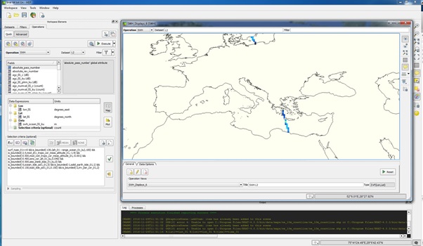
Sentinel-3 Altimetry toolbox provides a sub-set of pre-defined formulas for editing Sea Surface Height and Sea Level Anomaly formulas for different missions. Figure 1 shows the case of Sentinel-3.

Figure 1: Sentinel-3 data editing using S3 Altimetry toolbox
Sentinel-3 parameters are filled with a default value when these parameters have not been able to be computed. This default value is defined for each parameter in the "FillValue" field. Users could use several criteria to filter or discard these parameters value when they are set to default value.
Flags
Surface type flag (surf_type_[x1]_[x2]), surface classification flag (surf_class_[x1]_[x2]) and readiometer-derived surface type (rad_surf_type_[x1]_[x2]) prodive information about the surface type of the measurement (open_ocean, semin-enclosed-seas, land, continental_water, aquatic_vegetation, continental_ice, snow, floating_ice, salted_basin…). These flags could be used to filter the type of surface of the area of interest.
Distance to the coast parameter (dist_coast_[x1]_[x2]) could be used to filter measurements close to the coast ( coastal applications).
« Ocean » altimeter range validity flag (range_ocean_qual_[x1]_[x2]) indicates the use of not of the 20-Hz estimate of the "ocean" altimeter range when computing 1Hz estimate. « Ocean » backscatter coefficient validity flag (sig0_ocean_qual_[x1]_[x2]) indicates the use of not of the 20-Hz estimate of the "ocean" backscatter coefficient when computing 1Hz estimate.« Ocean » significant waveheight validity flag (swh_ocean_qual_[x1]_[x2]]) indicates the use of not of the 20-Hz estimate of the "ocean" significant waveheight when computing 1Hz estimate.
Rain flag (rain_flag_[x1]_[x2]) provides information about the probability of rain. This flag can be used to filter data with or without rain.
Ocean/Sea-ice flag (open_sea_ice_flag_[x1]_[x2]) could be used to filter different types of sea-ice measurements (e.g. first_year_sea_ice, wet_ice, multi_year_sea_ice, ambiguous_mixture_of_type…).
Mean sea surface interpolation flags (interp_flag_mss_sol1_[x1]_[x2] and interp_flag_mss_sol2_[x1]_[x2]) indicate if the interpolation of the mean sea surface solution is " good or bad". These flags could be used to filter "good or bad" interpolated measurements.
Mean dynamic topography interpolation flag (interp_flag_mdt_[x1]_[x2]) indicates if the interpolation of the mean dynamic topography solution is " good or bad". This flag could be used to filter "good or bad" interpolated measurements.
|
PARAMETER |
Waveforms Peakiness |
|
NETCDF NAME |
peakiness_1_[x1]_[x2] |
|
DESCRIPTION |
The ALT_MAN_QUA_03 algorithm computes peakiness 1 similar to the ENVISAT mission. |
|
UNITS |
10-3 counts |
|
DATA SET AVAILABILITY |
Reduced: none |
|
OPERATING MODE AVAILABILITY |
LRM (peakiness 1 only) and SAR (peakiness 2 only) |
|
DATA ORIGIN |
1 Hz Ku/C-bands: none |
|
ADDITIONAL INFORMATION |
None |
|
PARAMETERS RELATED |
None |
|
PARAMETER DETAILED DESCRIPTION |
ESA's Global Land and Ocean Mission for GMES Operational Services |
|
PARAMETER |
Interpolation flags |
|
NETCDF NAME |
interp_flag_mss_[x1]_[x2] |
|
DESCRIPTION |
Mean sea surface interpolation flag can be set to: |
|
UNITS |
None |
|
DATA SET AVAILABILITY |
Reduced: none |
|
OPERATING MODE AVAILABILITY |
LRM and SAR |
|
DATA ORIGIN |
1 Hz Ku/C-bands: GEN_ENV_MSS_01, GEN_ENV_MDT_01, GEN_ENV_TID_04, GEN_ENV_TID_03 and RAD_MAN_INT_03 algorithms. |
|
ADDITIONAL INFORMATION |
None |
|
PARAMETERS RELATED |
None |
|
PARAMETER DETAILED DESCRIPTION |
ESA's Global Land and Ocean Mission for GMES Operational Services |
|
PARAMETER |
Geophysical flags |
|
NETCDF NAME |
meteo_map_avail_[x1]_[x2] |
|
DESCRIPTION |
Meteorological map availability can be set to: |
|
UNITS |
None |
|
DATA SET AVAILABILITY |
Reduced: 1 Hz |
|
OPERATING MODE AVAILABILITY |
LRM and SAR |
|
DATA ORIGIN |
1 Hz Ku/C-bands: GEN_MAN_MET_01, ALT_PHY_GEN_02, GEN_ENV_SUR_02 and GEN_ENV_SUR_03 algorithms |
|
ADDITIONAL INFORMATION |
None |
|
PARAMETERS RELATED |
open_water_class_[x1]_[x2] |
|
PARAMETER DETAILED DESCRIPTION |
ESA's Global Land and Ocean Mission for GMES Operational Services |