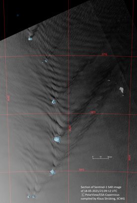
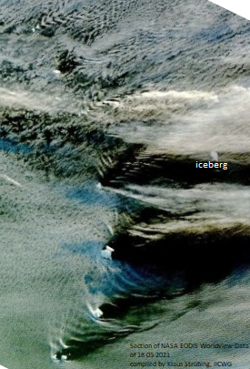
At the end of April, an iceberg with its longest axis of about 7.3 nm had been observed by Copernicus Sentinel-1 as it approached eastwards through the Scotia Sea, towards Saunders Island in the Southern Atlantic Ocean.
The drift of the iceberg was tracked since then, showing a rather surprising course. Both SAR and optical sensor images have presented interesting oceanographic and atmospheric phenomena, offering synchronous information over such large areas, which would not have been achieved by normal spot observations/measurements.
On 10 May, this same iceberg was spotted again by the Sentinel-1 satellites of the European Union’s Copernicus Programme, as shown in the following image. Furthermore, the image provides insight on oceanographic waves.
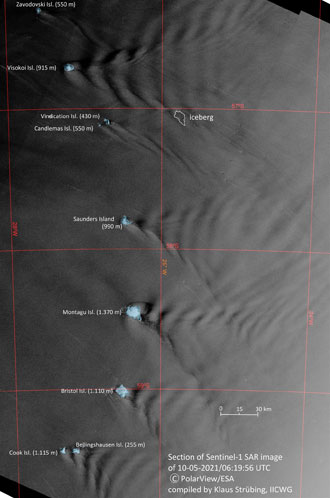
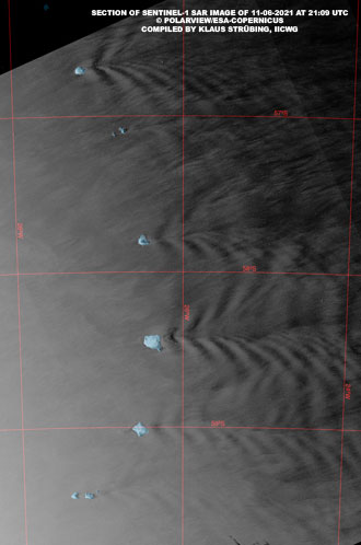
The iceberg was drifting about 50 km east of Candlemas Island. East of each of the South Sandwich Islands wavelike patterns were clearly visible. The patterns are created by the islands as obstacles for the currents and are the projection of relevant internal waves within the sub-surface layer of the ocean towards the sea surface. Nearly the same structure is shown in a recent image of 11 June.
On 18 May, the iceberg was spotted by both a NASA Earth Data satellite and by Copernicus Sentinel-1, giving us insight on the relevant atmospheric waves as well. They are reflected in the cloud patterns on the visual images of NASA’s satellites, which are also created by the islands with their volcanoes reaching up to 1550 m, creating obstacles for the wind flow.
Copernicus Sentinel-1 catches effect of islands on sea surface features
Since 30 April, when the berg was drifting north-eastwards away from Saunders Island, it was spotted again several times by Copernicus Sentinel-1’s SAR. The striking drift pattern is shown in Fig. 3 and presents some revealing information on the surface dynamics in the sea area east of the Sandwich Islands (See Image Descriptions for details).
The Copernicus Sentinel-1 mission includes C-band imaging operating in four exclusive imaging modes with different resolution (down to 5 m) and coverage (up to 400 km). It provides dual polarisation capability, very short revisit times and rapid product delivery.
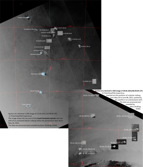
Synthetic Aperture Radar (SAR) has the advantage of operating at wavelengths not impeded by cloud cover or a lack of illumination and therefore can acquire data over a site during day or night time, under all weather conditions. Copernicus Sentinel-1, with its C-SAR instrument, can offer reliable, repeated wide area monitoring.
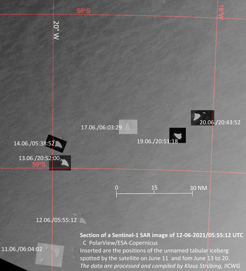
The berg has continued its voyage within the inner Weddel Gyre southwards instead of drifting further north eastwards for disintegration in warmer waters, and is now approaching the marginal ice zone.
Former Director and Professor at BSH, Klaus Strübing, Member Emeritus at the International Ice Charting Working Group, states, “Satellite images are showing not only extensive structures on the sea surface and in the atmosphere, which are reflecting dynamic processes of interest for related research in oceanography and meteorology, but the tracks of icebergs extracted from satellite data are also providing valuable data sets for this. Therefore, it is of basic interest for research and application that satellite programmes offer free, at least NRT data access as the mentioned ones are continued."
About the Copernicus Sentinels
The Copernicus Sentinels are a fleet of dedicated EU-owned satellites, designed to deliver the wealth of data and imagery that are central to the European Union's Copernicus environmental programme.
The European Commission leads and coordinates this programme, to improve the management of the environment, safeguarding lives every day. ESA is in charge of the space component, responsible for developing the family of Copernicus Sentinel satellites on behalf of the European Union and ensuring the flow of data for the Copernicus services, while the operations of the Copernicus Sentinels have been entrusted to ESA and EUMETSAT.
Did you know that?
Earth observation data from the Copernicus Sentinel satellites are fed into the Copernicus Services. First launched in 2012 with the Land Monitoring and Emergency Management services, these services provide free and open support, in six different thematic areas.
Thanks to iceberg detection through the Sentinel-1 mission (providing coverage through its two satellites), the Copernicus Marine Environment Monitoring Service (CMEMS) is able to deliver automated iceberg detection products to the international ice charting community, supporting them locally in securing shipping routes. The service also delivers real-time information and up to 10-day forecasts on ocean conditions, with data on waves, floating sea-ice concentration, thickness and drift.
CMEMS provides regular and systematic reference information on the physical and biogeochemical state, variability and dynamics of the ocean and marine ecosystems for the global ocean and the six European regional seas, including the Arctic and Baltic.
