Level-1 focused data are the products intended for most data users. The Level-0 product (raw data) is transformed into a Level-1 product by the Instrument Processing Facility (IPF) via the application of various algorithms as indicated below. These Level-1 products form a baseline product from which Level-2 products are derived.
The processing steps involved to produce Level-1 data products include pre-processing, Doppler centroid estimation, single look complex focusing, and image and post-processing for generation of the SLC and GRD products as well as mode specific processing for assembling of multiple sub-swath products.
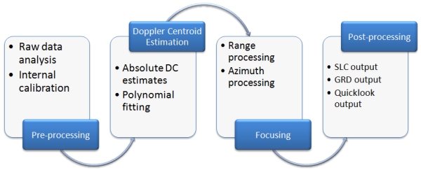
Level-1 Processing Flow
For converting digital pixel values to radiometrically calibrated backscatter, all the required information can be found in the product. A calibration vector is included as an annotation in the product allowing simple conversion of image intensity values into sigma or gamma nought values. Further details of how to calibrate Sentinel-1 Level 1 products can be found in the 'Radiometric Calibration of S-1 Level-1 Products Generated by the S-1 IPF' document ESA-EOPG-CSCOP-TN.
Level-1 data can be processed into either Single Look Complex (SLC) and/or Ground Range Detected (GRD) products. SLC products preserved phase information and are processed at the natural pixel spacing whereas GRD products contained the detected amplitude and are multi-looked to reduce the impact of speckle.
Single Look Complex
Level-1 Single Look Complex (SLC) products consist of focused SAR data, geo-referenced using orbit and attitude data from the satellite, and provided in slant-range geometry. Slant range is the natural radar range observation coordinate, defined as the line-of-sight from the radar to each reflecting object. The products are in zero-Doppler orientation where each row of pixels represents points along a line perpendicular to the sub-satellite track.
The products include a single look in each dimension using the full available signal bandwidth and complex samples (real and imaginary) preserving the phase information. The products have been geo-referenced using the orbit and attitude data from the satellite and have been corrected for azimuth bi-static delay, elevation antenna pattern and range spreading loss.
SM SLCs contain one image per polarisation for its single swath. IW, having three sub-swaths, has three images in single polarisation and six images for dual polarisation. EW, having five sub-swaths, has five images for single polarisation and ten images for dual polarisation products.
For IW and EW, each sub-swath consists of a series of bursts in azimuth. The individually focused complex burst data are included, in azimuth-time order, into a single sub-swath image, with black-fill demarcation in between.
For IW, a focused burst has a duration of ~2.75 seconds and a burst overlap of approximately ~0.4 seconds. For EW, a focused burst has a duration of ~3.19 seconds with an overlap of ~0.1 seconds. The overlap slightly increases in range within a sub-swath. This overlap is sufficient to provide contiguous coverage of the ground.
Images for all bursts in all sub-swaths of IW/EW SLC products are re-sampled to a common pixel spacing grid in range and azimuth. Burst synchronisation is maintained for both IW and EW products to ensure that interferometry between pairs of products acquired multiple repeat periods apart can be performed.
The Swath Timing data set record in SLC products contains information about the bursts including dimensions, timing and location that can be used to merge the bursts and swaths together.
Ground Range Detected
Level-1 Ground Range Detected (GRD) products consist of focused SAR data that has been detected, multi-looked and projected to ground range using the Earth ellipsoid model WGS84. The ellipsoid projection of the GRD products is corrected using the terrain height specified in the product general annotation.The terrain height used varies in azimuth but is constant in range (For IW/EW modes only the terrain height of first subswath is considered).
Ground range coordinates are the slant range coordinates projected onto the ellipsoid of the Earth. Pixel values represent detected amplitude. Phase information is lost. The resulting product has approximately square resolution pixels and square pixel spacing with reduced speckle at a cost of reduced spatial resolution.
For the IW and EW GRD products, multi-looking is performed on each burst individually. All bursts in all sub-swaths are then seamlessly merged to form a single, contiguous, ground range, detected image per polarisation.