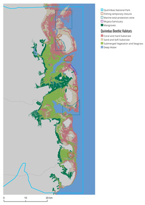
Mozambique has some of the most climate-resilient coral ecosystems worldwide - and one of the world's most important reefs - Copernicus Sentinel-2 data are helping to assess where they are and what is happening to them over time.
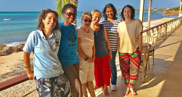
In 2018, satellite remote sensing expert Aurélie Shapiro of WWF Germany, launched an expedition with WWF-Mozambique, led by an international all-female team that used boats, depth finders, drones, apps and mobile phones to collect data on corals, seagrasses and mangroves, thus creating the first complete seascape map of the Quirimbas Archipelago in northern Mozambique.
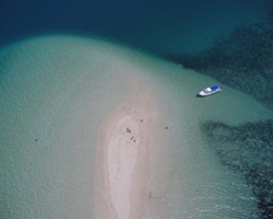
Occupying less than one percent of the ocean floor, coral reefs are home to more than twenty-five percent of marine life. The corals are essential nurseries for extremely diverse aquatic life, supporting thousands of fish species and crabs, which feed more than a million people. These habitats are associated with mangroves, seagrasses, sponges, even endangered dugongs, turtles and whales.
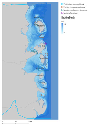
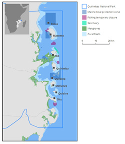
But Quirimbas is also home to over 100,000 local residents, most of whom depend on fish, crab, octopus and other sea life for their diets and livelihoods - therefore needing a sustainable and well managed fishery, which includes designated sanctuaries and zoned fishing areas.
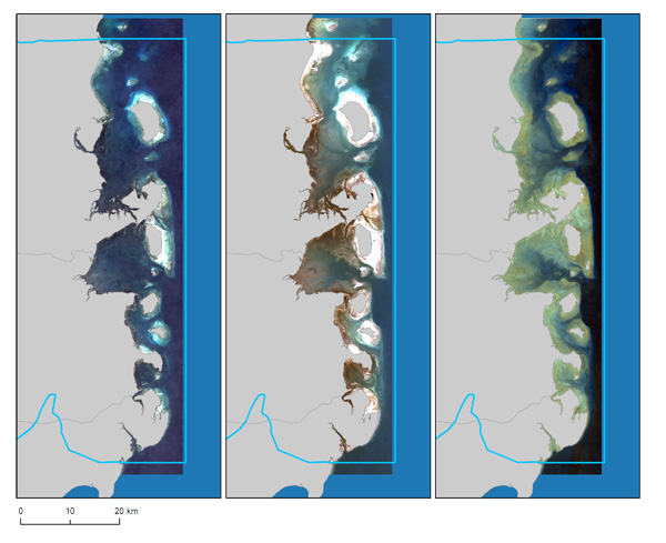
To manage the local resources for everyone, the WWF team used spatial data and maps, and partnered with the German aerospace centre (DLR) and the Foundation for Research and Technology – Hellas (FORTH) to apply new algorithms for processing Copernicus Sentinel-2 data.
Owing to a fully open data policy promoted by the EU, and making space data available worldwide to citizens using most common internet connection tools, Aurélie and her team accessed data from the Sentinel-2 mission of the European Union's Copernicus Programme, to get multispectral satellite images of the Mozambican coastline.
In order to train their machine learning algorithms, Aurélie and the team worked with local fishermen, partners from the National Park, as well as students, to collect data using three different drones, mobile phones, hand-held depth finders, glass bottomed buckets and GoPros to see what was really going on.
This, together with data that are consistent and stable over time, like those from Copernicus Sentinel-2, allowed them to assess the area progressively and to map it, to support future zoning efforts, such as delineating temporary closures or no fishing zones.
Copernicus Sentinel-2 carries an innovative wide swath high-resolution multispectral imager with 13 spectral bands. The combination of high resolution, novel spectral capabilities, a swath width of 290 km and frequent revisit times provides unprecedented views of Earth.
The mission is based on a constellation of two identical satellites in the same orbit, 180° apart for optimal coverage and data delivery. Together they cover all Earth's land surfaces, large islands, inland and coastal waters, every five days at the equator.
If optical imagery has been known for providing information for agricultural and forestry practices and determining various plant indices, coral monitoring demonstrates the full potential and promises of using Copernicus Sentinel-2 high resolution imagery in conjunction with more classical Copernicus Sentinel-3 ocean colour, to support environmental applications at sea linked to coastal and water quality monitoring.
Aurélie Shapiro, Remote Sensing Specialist at WWF Germany, states, "The improved spatial resolution of Copernicus Sentinel-2, along with the increased frequency of image collection compared to Landsat, has truly changed what is possible in terms of underwater mapping, particularly in tropical, cloudy regions like East Africa.
"We can combine enough images to make a cloud-free composite, and the data are really stable from year to year - which we hope to use to show bleaching or coral mortality," concluded Shapiro.
About the Copernicus Sentinels
The Copernicus Sentinels are a fleet of dedicated EU-owned satellites, designed to deliver the wealth of data and imagery that are central to the European Union's Copernicus environmental programme.
The European Commission leads and coordinates this programme, to improve the management of the environment, safeguarding lives every day. ESA is in charge of the space component, responsible for developing the family of Copernicus Sentinel satellites on behalf of the European Union and ensuring the flow of data for the Copernicus services, while the operations of the Copernicus Sentinels have been entrusted to ESA and EUMETSAT.
