In May 2023, Italy’s Emilia-Romagna region was hit by catastrophic floods that caused a loss of lives and left some thirteen thousand homeless—Copernicus Sentinel-2 proved to be a game-changer in identifying the aftermath’s mudslide locations.
The region was struck with the equivalent of six months' rainfall in just a day and a half, with over 20 rivers bursting their banks, forcing thousands to flee their homes.
Copyright: Bologna Today
Mudslides in Emilia Romagna
The result was infinite landslides over many villages—the worst disaster in a century, as Ravenna’s mayor told BBC.
Even weeks after the event, there was no full overview over the affected area, to assess the extent of the damage.
A team of remote sensing experts from the Swiss company, sarmap, were contacted to help create maps to delineate the exact overall locations.
They thought Synthetic Aperture Radar (SAR) would be the ideal candidate to generate such maps; however, the Sentinel-1 spatial resolution and its C-band wavelength were not as appropriate for this specific investigation.
The Sentinel-2 satellites of the European Union’s Copernicus Programme proved to be the best candidate, offering the only sensor providing regularly acquired data at the suitable spatial resolution (10m).Based on pre-event Sentinel-2 time-series, an almost cloud-free NDVI (Normalised Difference Vegetation Index) temporal composite was produced.
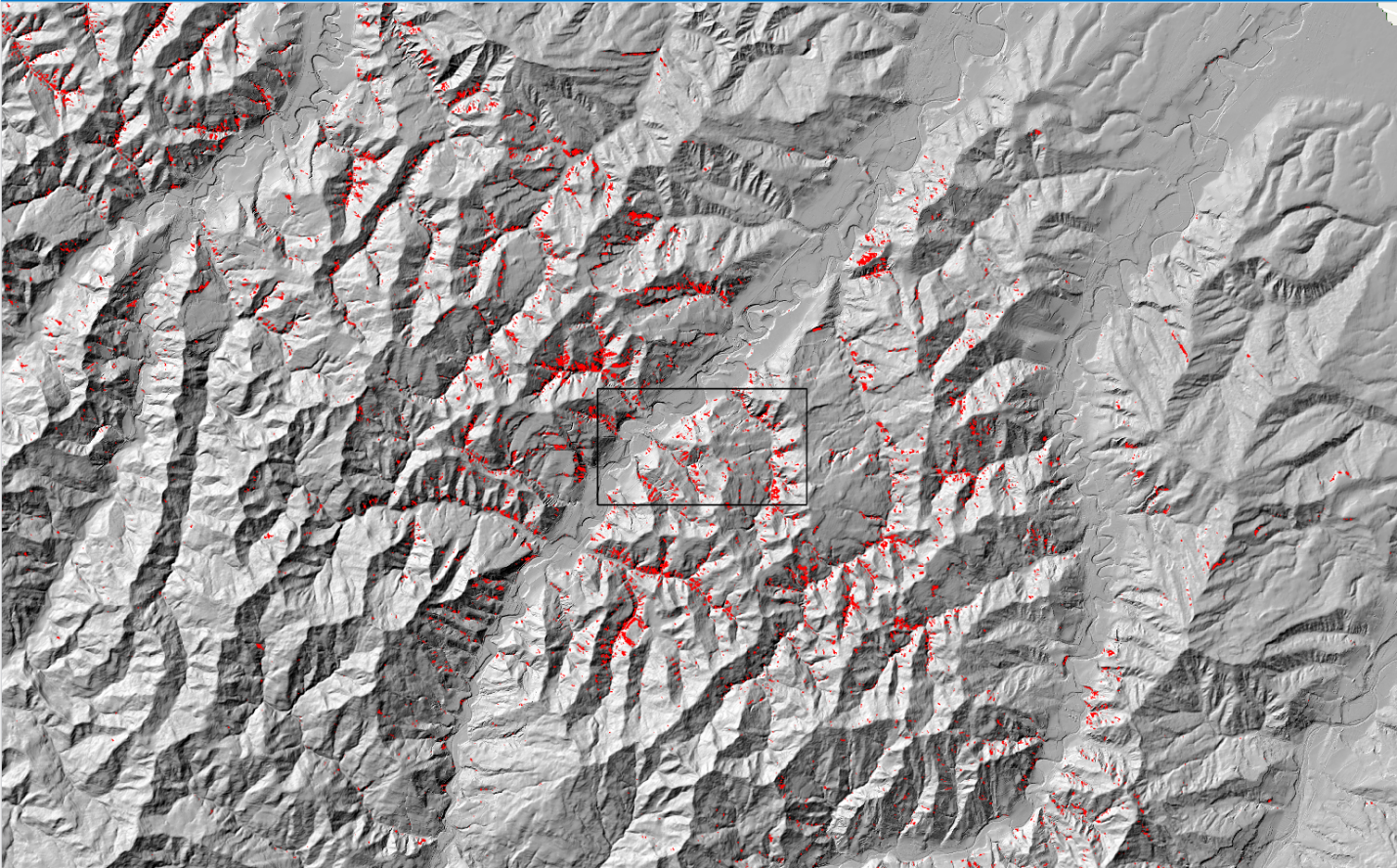
Copyright: Contains modified Copernicus Sentinel data (2023)/processed by sarmap (DTM 5x5 Ente Regione Emilia-Romagna)
Overview of mudslides
A difference was then generated between pre-event NDVI temporal composite and post-event NDVI Sentinel-2 data. This, in turn, was combined with the Lidar-DTM 5 meter and the permanent vegetation layer, publicly available, hence enabling to identify mudslides and soil washout in permanently vegetated sloped areas. The use of the permanent vegetation layer contributed to discarding false mudslides and soil washout in sloped agricultural fields and grassland.
Copyright: Contains modified Copernicus Sentinel data (2023)/processed by sarmap (DTM 5x5 Ente Regione Emilia-Romagna)
Overview of mudslides
Copyright: Contains modified Copernicus Sentinel data (2023)/processed by sarmap
Sentinel-2 over the flood areas
Validation was carried out by comparing the Copernicus Sentinel-2 derived product over some areas with the few existing PlanetScope images acquired pre- and post-event, and by photo-interpreting mudslides and soil washout derived from a SkySat post-event image. Based on the above described methodology, the (150 km by 50 km) area under investigation was mapped within one day.
Copyright: Planet Labs 2023/processed by sarmap
PlanetScope
“In short, the sarmap team discovered Copernicus Sentinel-2’s capability to provide a rapid mapping of such events, thus contributing to guide terrestrial interventions and detailed mapping using very high resolution satellite or drone data”, asserted Francesco Holecz, co-founding owner and CEO of sarmap.
About the Copernicus Sentinels
The Copernicus Sentinels are a fleet of dedicated EU-owned satellites, designed to deliver the wealth of data and imagery that are central to the European Union's Copernicus environmental programme.
The European Commission leads and coordinates this programme, to improve the management of the environment, safeguarding lives every day. ESA is in charge of the space component, responsible for developing the family of Copernicus Sentinel satellites on behalf of the European Union and ensuring the flow of data for the Copernicus services, while the operations of the Copernicus Sentinels have been entrusted to ESA and EUMETSAT.
Did you know that?
Earth observation data from the Copernicus Sentinel satellites are fed into the Copernicus Services. First launched in 2012 with the Land Monitoring and Emergency Management services, these services provide free and open support, in six different thematic areas.
The Copernicus Land Monitoring Service (CLMS) provides geographical information on land cover and its changes, land use, vegetation state, water cycle and Earth's surface energy variables to a broad range of users in Europe and across the World, in the field of environmental terrestrial applications.
It supports applications in a variety of domains such as spatial and urban planning, forest management, water management, agriculture and food security, nature conservation and restoration, rural development, ecosystem accounting and mitigation/adaptation to climate change.
