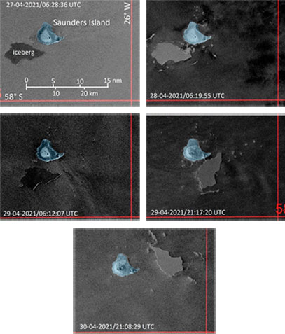
Title: 87 hours of Sentinel-1 coverage over Saunders Island
Description: The presented sections of Copernicus Sentinel-1 SAR images are separated by 24 hours (2a to 2c and 2d to 2e) and 15 hours (2c to 2d). During this period of 77 hours total, the iceberg passed the southern coast of Saunders Island at a distance of less than 2 km at most. During the eastward drift, the iceberg rotated anticlockwise by about 140 degrees. A collision with the coast on 29 April (figure 2d), as result of the rotation could be possible. The distance on the image is only about 500 m.
- Figure 2a: Initial position of the tabular iceberg on 27 April, some 3 km off the coast
- Figure 2b: 24 hours later, the situation has not changed very much. However, debris from the berg has drifted much closer towards the coast, documenting its disintegration.
- Figure 2c: Within 24 hours, the iceberg has drifted about 6.5 km eastwards, but without an essential approach towards the coast. A slight anticlockwise rotation has started.
- Figure 2d: During the last 15 hours, a further eastward drift of approximately 10 km can be measured. However, as a more striking event within this period the anticlockwise rotation of about 60 degrees can be recognised. By this dynamic, the northern front of the berg has approached the coast by less than 500 m, according to this snap-shot of Copernicus Sentinel-1. Much debris is drifting south and eastwards from the iceberg.
- Figure 2e: During the last 24 hours in this time-frame, the iceberg left Saunders Island by a north-eastwards drift of about 16 km and further anticlockwise rotation of nearly 80 degrees
Copyright: Contains modified Copernicus Sentinel data (2021)/ processed by K. Strübing
