Forestry
Sentinel-1 can play an important role in sustainable forest management with clear-cut and partial-cut detection, forest type classification, biomass estimation and disturbance detection. For climate change, mapping of forest fire scars can be an important part of mapping the carbon history of a forest and plays a critical role in the estimation of carbon emissions.
Land cover maps can be used to support forest management and the monitoring of illegal timber harvesting worldwide.
Figure 1: Forest Cover Monitoring with Sentinel-1
Agriculture
Monitoring of crop conditions, soil properties and mapping tillage activities, help to assess land use, predict harvests, monitor seasonal changes and assist in implementing policy for sustainable development. Sentinel-1 can also be used for monitoring the changes of agricultural production and productivity of pastures caused by drought and monitoring the decline of land productivity and soil degradation due to excessive cultivation and pasturage and improper irrigation.
Agricultural maps enable provision of independent and objective estimates of the extent of cultivation in a given country or growing season, which can be used to support efforts to ensure food security in vulnerable areas.
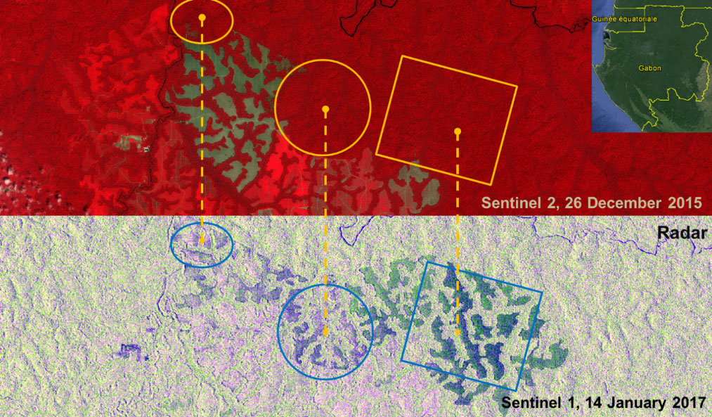
Figure 2: Monitoring of expansion of rubber plantation with Sentinel-2 / Sentinel-1. Contains modified Copernicus data [2015-2017], processed by SIRS.
Urban Deformation Mapping
Interferometric SAR can detect surface movements with an accuracy of a few millimetres per year and can provide an accurate tool for monitoring of land subsidence, structural damage and underground construction to improve safety and reduce economic loss.
Figure 3: Subsidence monitoring of Venice, Italy with Sentinel-1 (provides the means for continuous monitoring of ground movement with an accuracy of a few millimetres per year).