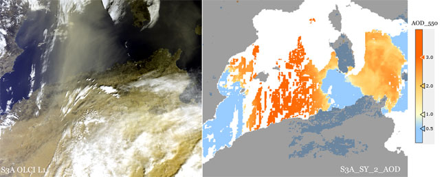
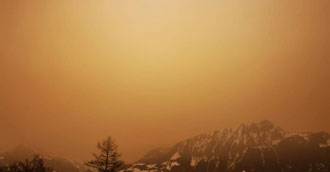
On 6 February 2021, a huge windstorm from the Sahara reached large parts of the Alps and Pyrenees, giving the snow and surrounding area a sepia coloured nuance, and creating a Mars-like atmosphere—Copernicus Sentinel-3 caught it in real-time, adding to its ability of supplying aerosol estimates.
The phenomenon of Saharan sandstorms reaching Europe can occur various times throughout winters.
Strong southerly winds in Africa took the sand into the sky, atmospheric air currents pushed it northwards and when it hit the mountain ranges of Europe it descended, covering the surroundings like an orange blanket.
The OLCI (ocean and land cover instrument) sensor on the Sentinel-3 mission of the European Union's Copernicus Programme caught the drift of the sandstorm, as shown in the featured images.
Recently, satellite remote sensing and ground-based observations have become widely used to monitor the spatial and temporal distributions of aerosols on a global and local scale.
Carrying a suite of cutting-edge instruments, Copernicus Sentinel-3 measures systematically Earth's oceans, land, ice and atmosphere to monitor and understand large-scale global dynamics. It also provides essential information in near-real time for ocean and weather forecasting.
The mission is based on two identical satellites orbiting in constellation for optimum global coverage and data delivery. For example, with a swath width of 1270 km, the ocean and land colour instrument provides global coverage every two days.
Copernicus Sentinel-3A was launched on 16 February 2016, followed by its twin on 25 April 2018, and they supply the coverage and data delivery needed for Europe's Copernicus environmental monitoring programme.
Carrying four instruments that work in synergy, Copernicus Sentinel-3 is the most complex of all the Sentinel missions.
The Ocean and Land Colour Instrument is based on heritage from Envisat's Medium Resolution Imaging Spectrometer and features 21 distinct bands in the 0.4–1.02 µm spectral region (or 400 - 1020 nm) tuned to specific ocean colour, vegetation and atmospheric correction measurement requirements. It has a spatial resolution of 300 m for all measurements and a swath width of 1270 km, overlapping the SLSTR (Sea and Land Surface Temperature Radiometer) instrument's swath.
The SLSTR measures global sea- and land-surface temperatures every day to an accuracy of better than 0.3 K. Continuing the legacy of Envisat's Advanced Along Track Scanning Radiometer, it maintains a dual-view along-track-scanning approach and delivers measurements at a spatial resolution of 500 m for visible/near-infrared and short-wavelength infrared channels and at 1 km for the thermal infrared channels.
Furthermore, SLSTR includes two dedicated thermal infrared channels that are optimised for active fire detection and fire radiative power measurement – fundamental for Copernicus Emergency Response and Climate Services.
Aerosol optical depth (AOD) is one of the essential atmospheric parameters for climate change assessment. Atmospheric aerosol is the most common type of dispersal system under natural conditions, consisting of solid and liquid particles, suspended in the atmosphere.
As explained in a 2019 article on Nature, "Atmospheric aerosols, such as those from the burning of biomass, dust minerals, volcanic ash, smoke, sea salt and particulate matter, stand out as a result of various natural and anthropogenic influences. They are important components in the Earth's system and have a decisive influence on global and regional climate change, air quality, human health, flora and fauna through the direct and indirect radiation forcing, and also have a direct impact on cloud processes, visibility variation. In addition, aerosols have a significant impact on the concentration, distribution and hydrological cycle of greenhouse gases, affecting the physical and chemical processes in the atmosphere".
OLCI's eyes on Earth, combined with those of SLSTR, provide estimates of atmospheric aerosol and clouds. The SYNERGY Level-2 global Aerosol product contains both retrieved and diagnostic global aerosol parameters in a single measurement dataset, at 4.5 km resolution for all regions over land and ocean free of snow/ice cover, and excluding high cloud fraction.
The Level-2 SYN AOD product (SY_2_AOD) is produced by a dedicated synergy processor combining Level 1 OLCI and SLSTR data and a global synergy level 2 processing module retrieving, over land and sea, aerosol optical thickness. The resolution of this product is wider than classic Copernicus Sentinel-3 products, as the datasets are provided at a 4.5 km resolution.
Anja Stromme, ESA's Sentinel-3 Mission Manager, states, "The SYNergy AOD product brings together the respective strengths of the two optical sensors onboard Copernicus Sentinel-3 - the OLCI and SLSTR instruments - in order to perform the complex retrieval of AOD by combining their individual eyes, thus highlighting the benefit of a multi-instrument platform."
About the Copernicus Sentinels
The Copernicus Sentinels are a fleet of dedicated EU-owned satellites, designed to deliver the wealth of data and imagery that are central to the European Union's Copernicus environmental programme.
The European Commission leads and coordinates this programme, to improve the management of the environment, safeguarding lives every day. ESA is in charge of the space component, responsible for developing the family of Copernicus Sentinel satellites on behalf of the European Union and ensuring the flow of data for the Copernicus services, while the operations of the Copernicus Sentinels have been entrusted to ESA and EUMETSAT.
Did you know that?
The Copernicus Atmosphere Monitoring Service (CAMS) is one of six services that form the Copernicus EO programme, providing consistent and quality-controlled information related to air pollution and health, solar energy, greenhouse gases and climate forcing, everywhere in the world. CAMS air quality forecasts showed a great plume of Saharan dust moving towards Southern and Central Europe. The main volume of dust was expected to centre over eastern Spain and southern France, but forecasts suggested it might reach as far as Norway.
CAMS is implemented by the European Centre for Medium-Range Weather Forecasts (ECMWF) on behalf of the European Commission. ECMWF is an independent intergovernmental organisation supported by 34 states. It is both a research institute and a 24/7 operational service, producing and disseminating numerical weather predictions to its member states.


