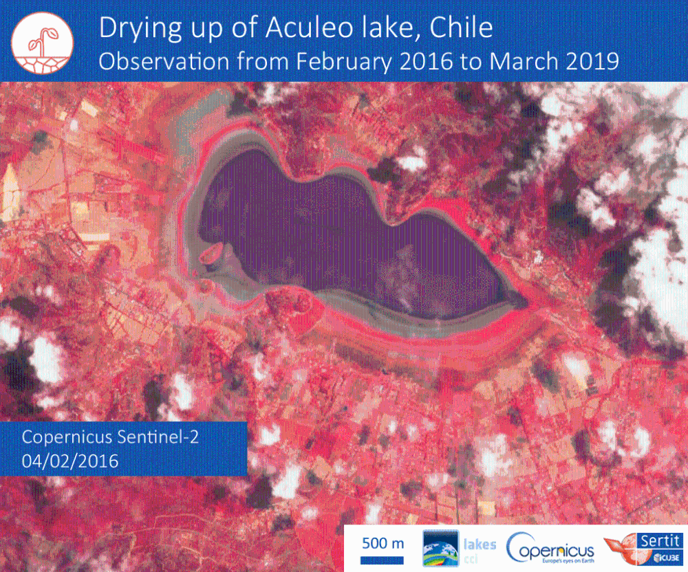
The complete drying-up of Lake Aculeo in Chile was captured by the Copernicus Sentinel-2 satellite, enabling scientists to follow the water surface extent at high frequency, and thus witness this dramatic loss.
In just three years, the Aculeo Lake, near Santiago de Chile, has completely disappeared, victim of a persistent drought and overconsumption of water. The times series from the Sentinel-2 satellites of the European Union's Copernicus Programme made it possible to observe the lake's declining water level until it fully faded.
In the framework program of the Climate Change initiative (CCI), ESA aims to measure some key variables for climate studies, defined as Essential Climate Variables (ECVs).
For this program, the CCI-Lakes project is associated with studying the water level, water temperature, ice coverage and water colour of lakes. The water extent of lakes is considered as an ECV since the dynamic of water extent over a lake is an indicator of the impact of climate change on Earth's water resources.
The University of Strasbourg's ICube-SERTIT is a technology transfer platform that aims to extract and format information from image data, produced by Earth Observation systems. It is involved in the CCI Lakes project in testing methods for deriving water surfaces from SAR and optical satellite images.
ICube-SERTIT is an intermediary between space research, digital technologies and operational user needs, with a multi-disciplinary team comprised of 20 specialists (IT, geologists, physicists, geographers, land surveyors) with high-level technical skills in satellite image processing, remote sensing, GIS (Geographical Information Systems), and in photogrammetry.
This team observes and monitors changes in the behaviour of lakes worldwide. Lakes are sentinels, regulators and integrators of climate change, and satellite remote sensing is the most suitable tool to observe lake-atmosphere interactions with climate change, at a global scale.
Satellite measurements make it possible to produce and validate consistent data on ECVs for lakes, and the richness of Copernicus Sentinel-2 data make it possible to monitor both huge lakes of hundreds of square kilometres as well as small lakes of tens of square kilometres. It may be sufficient to capture seasonal effects (emptying or infilling) or drought effects, taking advantage of the high-revisit frequencies thanks to the two Copernicus Sentinel-2 satellites.
The 12 km2 Aculeo Lake was a water resource for agriculture (avocado cultures, which require abundant water) and a very important leisure area for citizens of Santiago, which is considered a major tourist destination. The agriculture of the area demanded a greater amount of water for irrigation, which led to an over exploitation of the lake water, also amplified by a uncontrolled expansion of residential villas with pools on the lake's shores.
In the featured time series, we can see a general decrease of the water surface, with a dramatic outcome in December 2018, when no more water was detected and vegetation started to develop on the mud crust.
This was tragic not only for the local population due to the loss of tourism, but also for the loss of water resources for agriculture. 70% of the Chilean population is threatened by drought and scientists estimate that temperatures will continue to increase in the next 15 years, while hydrography resources in Central Chile will see a decrease of 30%.
Dr Bruno Coulon, Project Manager of the Lakes CCI project, states, "Satellite remote sensing is a very well-suited technology for monitoring the variety of parameters that are part of a lake and that could influence climate or be a climate change indicator. In the context of Lakes CCI, the first coherent dataset containing these parameters from different satellites and sensors will be developed. It will include lake water extent and level, ice cover, surface temperature and surface reflectance. Times series, like that for Aculeo Lake, will then be available."
About the Copernicus Sentinels
The Copernicus Sentinels are a fleet of dedicated EU-owned satellites, designed to deliver the wealth of data and imagery that are central to the European Union's Copernicus environmental programme.
The European Commission leads and coordinates this programme, to improve the management of the environment, safeguarding lives every day. ESA is in charge of the space component, responsible for developing the family of Copernicus Sentinel satellites on behalf of the European Union and ensuring the flow of data for the Copernicus services, while the operations of the Copernicus Sentinels have been entrusted to ESA and EUMETSAT.

