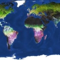
Billions of image pixels recorded by the Copernicus Sentinel-2 mission have been used to generate a high-resolution map of land-cover dynamics across Earth's landmasses. This map also depicts the month of the peak of vegetation and gives new insight into land productivity.
Billions of image pixels recorded by the Copernicus Sentinel-2 mission have been used to generate a high-resolution map of land-cover dynamics across Earth's landmasses. This map also depicts the month of the peak of vegetation and gives new insight into land productivity.
Using three years' worth of optical data, the map can indicate the time of vegetation peak and variability of vegetation across seasons. Developed by GeoVille, an Austrian company specialised in the analysis of satellite data, this land-cover map dynamics map uses Copernicus Sentinel-2 archive data from 2015-18, and gives a complete picture of variations of vegetation. The map is displayed at a resolution of 20 m, however a 10 m version is available on request.
It can, for example, support experts working with land-cover classification and can serve as input for services in areas such as agriculture, forestry and land-degradation assessments.
