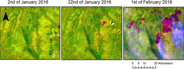
Images from Sentinel-1 and Sentinel-2 have been combined to reveal that 36,000 ha of forest has burnt in the Republic of Congo in Africa.
At the beginning of 2016, during a very strong El Niño, an unusual number of fires broke out in forests in the north of the country.
During the peak, in the early part of the year, fire was spreading at a rate of 1600 ha a day.
Fire is very common in Africa, but in the Republic of Congo it is usually too humid for forests to burn.
The main commercial activity in the area is the extraction of round wood from areas leased from the national authorities by private companies. These cover an extensive part of forest in the north of the country including the Marantaceae forests, which were affected by the fires.
These forests are not only an important habitat for large mammals such as gorillas and forest elephants, but they also store large quantities of carbon.
Thanks to the European Union's Copernicus free and open data policy through which data from the Sentinels are available, a consortium, led by the Joint Research Centre (JRC), showed that data from Sentinel-1A and Sentinel-2A could be combined to map the extent and dynamics of these fires. Each satellite's sensor compensates for the difficulty of the other (cloud perturbations for Sentinel-2 and sensitivity to ground moisture for Sentinel-1).
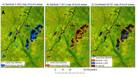
Burnt areas mapped by Sentinel-1's synthetic aperture radar and Sentinel-2's multispectral imager highlighted that the fires occurred mainly in the Marantaceae forests. These forests typically have an open tree canopy and an extensive tall herbaceous layer. The maps show that the origin of the fires correlates with accessibility to the forest, suggesting they were caused by human activity (Verhegghen et al, 2016).
With a temporal resolution of 10 days and a spatial resolution of 10 m, Sentinel-2A images allow the timing and extent of fire events to be mapped precisely. The mission's temporal resolution will increase to five days when Sentinel-2B is fully operational in October 2017 after commissioning. This is an improvement on the temporal resolution of 16 days and spatial resolution of 30 m that Landsat-8 provides.
However, the Congo Basin is typically shrouded in cloud throughout the year, which limits the suitability of optical sensors to map the region. Sentinel-1 can complement Sentinel-2 thanks to its radar's sensitivity to vegetation and day and night observing capabilities.
Other maps showing burnt areas were generated by scientists from the ReCaREDD project using images acquired by Sentinel-1A between 1 November 2015 and 30 April 2016, and images captured by Sentinel-2A between 3 December 2015 and 21 May 2016.
The maps were then combined at a 20-m resolution. Three different scenarios were foreseen when generating the map composite. The different results were presented and discussed, but the final goal was to combine Sentinel-1-based and Sentinel-2-based maps to take advantage of the sensors' complementarity.
Sentinel-1 and Sentinel-2 data can now be used to detect and monitor outbreaks of fire in forests at finer temporal and spatial resolution than was previously possible.
The fifteen Sentinel-2A images analysed from December 2015 to May 2016 represented the first time series of Sentinel-2 data over the study area, demonstrating a great potential for tropical forest monitoring applications.
The burnt area maps derived from each Sentinel-2 image added a precise spatial extent to the point location of the MODIS active fire product, providing better documentation of fire propagation in the Marantaceae forests.
The two burnt area maps derived from Sentinel-1A bi-monthly composites provided a gap filling capacity (in case of cloud cover), contributing confidence to the Sentinel-2 results, with over 60% concurrence between the two datasets.
Dr Valery Gond, senior scientist at CIRAD, said, "These results show that we now have the capacity to use Sentinel constellations to detect disturbances very quickly and monitor remote areas in the tropical forest belt."
Scientific project officer at the Joint Research Centre, Dr Astrid Verhegghen, says, "The combination of Sentinel-1 and Sentinel-2 data allows us to exploit the Sentinels in a way that really improves the robustness of burnt area detections, each sensor contributing its particular strength."
The success of the Sentinel-1 and -2 satellites, soon to be supported by Sentinel-3's Sea and Land Surface Temperature Radiometer, which has bands optimised for active fire monitoring, can provide forest managers and national agencies with a rapid and accurate assessment of fires.
Such user groups can also consider products from the Copernicus Services that relate to forest fires, for instance, Global Wildfire Information System, which is a part of the Copernicus Emergency Management Service; emission estimates from wildfires produced within the Global Fire Assimilation System, which contribute to the forecast of atmospheric composition in the Copernicus Atmosphere Monitoring System, as well as Land Surface Temperature and Burnt Area from the Copernicus Global Land Service.
About the Sentinels
The Sentinels are a fleet of dedicated EU-owned satellites, designed to deliver the wealth of data and imagery that are central to Europe's Copernicus environmental programme.
In partnership with EU Member States, the European Commission leads and coordinates this programme, to improve the management of the environment, safeguarding lives every day. ESA is in charge of the space component, responsible for developing the family of Copernicus Sentinel satellites and ensuring the flow of data for the Copernicus services, while the operations of the Sentinels have been entrusted to ESA and EUMETSAT.


