Feedback from the Sentinel-3 Validation Team meeting provided essential information to ESA and EUMETSAT to progress with the evolution and improvement of Sentinel-3's core data products.
ESA and EUMETSAT set up the Sentinel-3 Validation Team (S3VT) based on experience from previous missions. The team is comprised of a group of scientists and experts that have a long-running world-class competence in the type of measurements provided by the Sentinel-3 mission.
Carrying a suite of cutting-edge instruments, the Copernicus Sentinel-3A satellite systematically observes Earth's oceans, land and ice surfaces and the atmosphere to monitor and understand, amongst other aspects, large-scale global dynamics. Designed as a two-satellite constellation, the mission optimises global coverage and data delivery for the Copernicus services.
Focusing on oceans, Sentinel-3 measures the temperature, colour and height of sea surface, as well as the thickness of sea ice. Over land, this innovative mission provides a bigger picture by monitoring wildfires, mapping the characteristics of land surfaces, providing indices of vegetation state and measuring the height of rivers and lakes.
Sentinel-3A was launched on 16 February 2016 and passed the in-orbit commissioning review in July 2016. At the end of 2017 its identical twin, Sentinel-3B, will follow, completing the first pair of the constellation in orbit.
Like all satellite data, Sentinel-3 data products need a continuous effort of scientific validation activities to ascertain the accuracy of the measurements of the various geophysical variables being monitored.
With such objectives in mind, ESA and EUMETSAT recently held the Sentinel-3 validation team meeting in ESA's Centre for Earth Observation (ESRIN). Experts from around the world discussed the results of the initial validation activities since Sentinel-3A's launch, dividing them into four subgroups: Sea Surface Temperature, Ocean Colour, Altimetry and Land Surfaces.
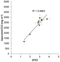
Scientists from the University of Southampton attempted to validate two of Sentinel-3's Ocean and Land Colour Instrument (OLCI) vegetation products: the OLCI Global Vegetation Index (OGVI), providing the Fraction of Absorbed Photosynthetically Active Radiation (FAPAR) and the OLCI Terrestrial Chlorophyll Index (OTCI), which supply indication of the content of Chlorophyll in the vegetation canopy.
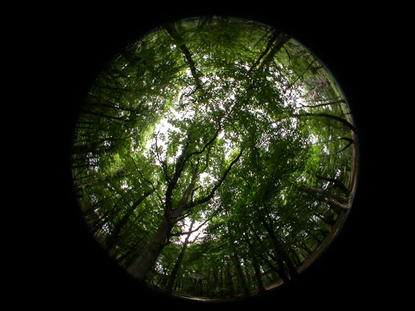
A series of field campaigns were carried out in a deciduous forest in southern England. During the growing season of 2016, Leaf Area Index (LAI) and chlorophyll concentration data were systematically collected eight times during the year, across nine sampling units. This field dataset had a strong positive relationship with Sentinel-3's vegetation products.
Jadu Dash, Professor in Remote Sensing at the University of Southampton, said, "Further validation activities in future would characterise detail accuracy and uncertainties of these products.
"This current campaign is an important first step to perform a systematic quality-check in the earlier days of the mission."
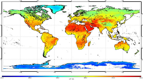
Dealing with Sentinel-3's Sea and Land Surface Temperature Radiometer (SLSTR) products, experts from the University of Leicester worked on Land Surface Temperature (LST) validation activities.
LST is a fundamental indicator in the physics of land-surface processes at local through global scales, and has been included as a new Essential Climate Variable (ECV) in the 2016 GCOS (Global Climate Observing System) Implementation Plan.
The Sentinel-3 Cal-Val Plan for evaluating the core level-2 LST product from SLSTR (SL_2_LST) builds on an established validation protocol for satellite-based LST. This set of guidelines provides a standardised framework for structuring LST validation activities, based around a multipronged approach which includes: i) in-situ validation where high quality ground-based observations are available; and ii) intercomparing with retrievals from other satellite sensors.
Findings from initial validation using in-situ observations indicate that the SL_2_LST product is performing near to the mission requirement (S3-MR-420), which states that SLSTR shall be able to measure LST to an accuracy of <1 K. Utilising the re-processed data from 12 July 2016 to 15 November 2016, intercomparing to the state-of-art MODIS product from ESA's DUE GlobTemperature Project of (quasi) simultaneous nadir overpasses, shows that the difference between these products is <1 K for all regions and all months.
Dr Darren Ghent, LST Validation Scientist for the Sentinel-3 mission at the National Centre for Earth Observation (NCEO) of the University of Leicester, said, "To fully exploit LST from Sentinel-3 it is essential that rigorous validation activities are carried out to determine the accuracy and precision of the retrieval algorithm.
"These first validation results are an important step to convey integrity of the product, as we move towards exploitation by the wider science community and operational services."
Sentinel-3 is providing key observations addressing cryosphere's evolution given that decreasing snow cover is one of the clearest indicators of a warming climate. Snow has a major influence on Earth's radiation balance and it is also a very sensitive indicator of high latitude climate change, being closely related to shifts in temperature and precipitation regimes.
Owing to its importance, snow albedo or reflectivity has been designated as an ECV and a Target Requirement for climate monitoring.
A team lead by Professor Jason Box at the Geological Survey Denmark and Greenland, (GEUS) approaches the snow problem in two ways. Firstly, by studying the feasibility and benefit of snow model data assimilation of Sentinel-3's optical data.
Within this work frame, Marie Dumont, Head of the snowpack observation and modelling team from Centre d'Etudes de la Neige (CNRM/Meteo France-CNRS UMR3589) in Grenoble, will push data assimilation capabilities to the near-real time frame, thus serving operational models to improve flood and avalanche hazard forecasting.
Another aspect of work related to snow involves field campaigns throughout 2017 and 2018 in Greenland, the French Alps and Antarctica.
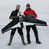
In Greenland, validation involves fixed-wing drone technology from Aberystwyth University, Wales, supported by the Glaciology Professor at GEUS, Jason Box, who said, "We're planning to under-fly Sentinel-3 in June 2017 with a 2 m fixed-wing drone, carrying four bands matching Sentinel-3 and with significant overlap with NASA's MODIS.
"The drone flights, combined with ground measurements of snow crystal morphology and impurity content, give us closure on bridging Sentinel-3 with MODIS to build a Climate Data Record of snow properties, identified as an Essential Climate Variable."
About the Sentinels
The Sentinels are a fleet of dedicated EU-owned satellites, designed to deliver the wealth of data and imagery that are central to Europe's Copernicus environmental programme.
In partnership with EU Member States, the European Commission leads and coordinates this programme, to improve the management of the environment, safeguarding lives every day. ESA is in charge of the space component, responsible for developing the family of Copernicus Sentinel satellites and ensuring the flow of data for the Copernicus services, while the operations of the Sentinels have been entrusted to ESA and EUMETSAT.
