Australia has been struggling with severe bushfires for months now, and while experts are using all the satellite data they can to help monitor the situation, new products from the Copernicus Sentinel-3 mission will provide Fire Radiative Power information and aerosol parameters.
Record-breaking temperatures and months of extreme drought have helped trigger a series of massive bushfires across parts of Australia. Hot, dry weather together with prolonged drought and strong winds produced perfect conditions for the wildfires to rapidly spread, with more than 6.3 million hectares (63,000 sq km or 15.6 million acres) of bush, forest and national parkland already burned.
Humans are sometimes responsible for igniting such wildfires, but often the cause is lightning impacting dry vegetation. In extreme cases, bush fires can also prompt meteorological conditions such as thunderstorms, increasing the risk of lightning strikes and further fires, thus fuelling themselves. This appears to be the case for at least some of the current Australian blaze.
The Australian Bureau of Meteorology also states that since 1910 Australia has warmed overall by slightly more than one degree Celsius, with most of the heating occurring since 1950. Whilst the extreme weather experienced recently in Australia may be largely related to an unusually strong imbalance in water temperature between two regions of the Indian Ocean (the so-called Indian ocean dipole), continuing changes in the climate may also increase the probability of weather extremes and thus extreme fires in the future.
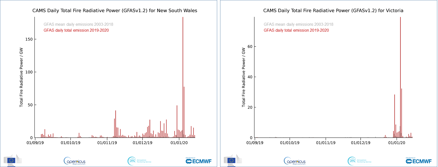
As well as dramatic changes to Earth's surface, fires such as those burning in Australia induce significant effects on Earth's atmosphere. The Global Fire Assimilation System (GFAS) operated as part of the Copernicus Atmosphere Monitoring Service (CAMS) assimilates fire radiative power (FRP) observations from satellite-based sensors to produce daily estimates of global biomass burning smoke emissions.
GFAS also produces information regarding what height the smoke is injected into the atmosphere, a parameter that impacts where the smoke is transported to, derived from a model that uses the FRP data combined with operational weather forecasts from ECMWF (the European Centre for Medium-Range Weather Forecasts) who operate CAMS. 
ECMWF is both a research institute and a 24/7 operational service, producing global numerical weather predictions and other data for their Member and Co-operating States and the broader community.
As well as CAMS, ECMWF operates a second service for the EU's Copernicus Earth observation programme, the Copernicus Climate Change Service (C3S), while also contributing to the Copernicus Emergency Management Service (CEMS).
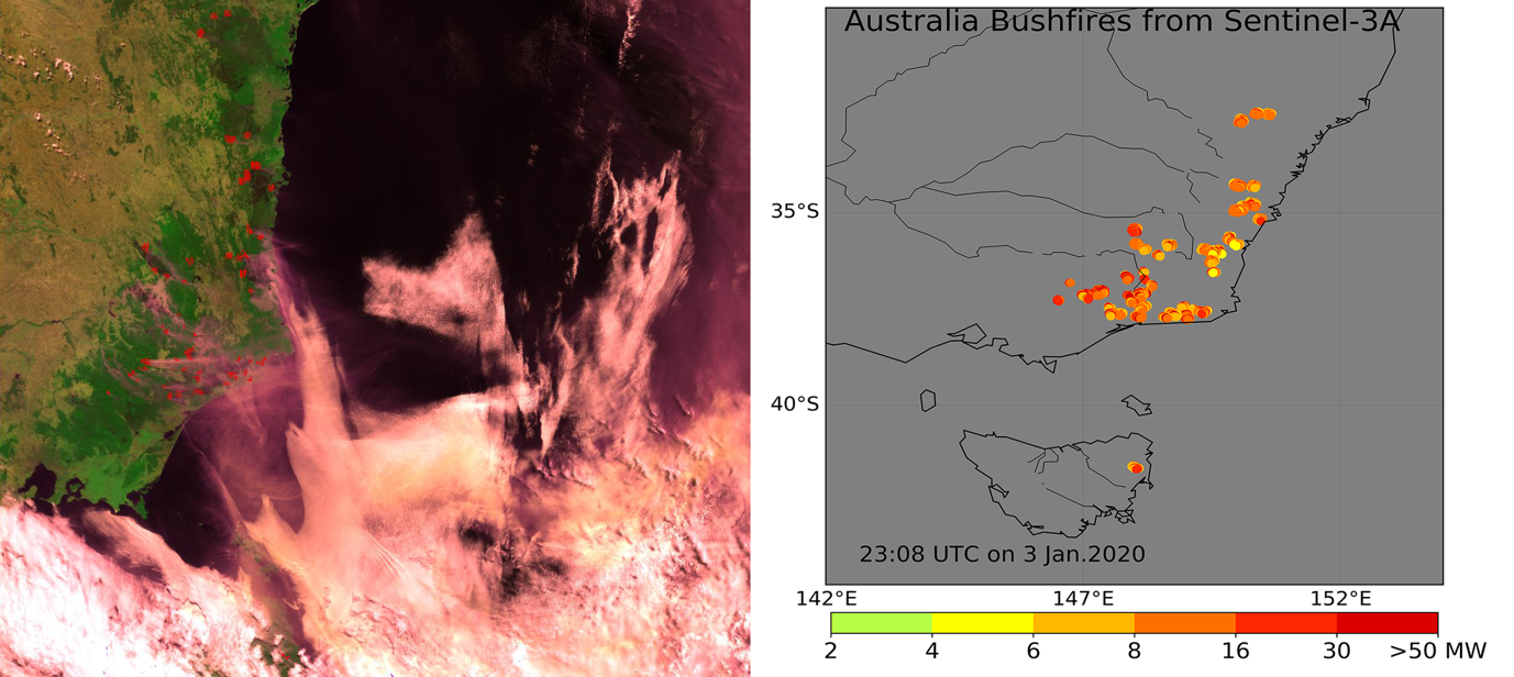
Within the Copernicus Sentinel-3 Mission Performance Centre (S3-MPC) framework, ESA has developed a new product that uses infrared sensing to detect fires as they are burning and which also quantifies their thermal emission (the so-called Fire Radiative Power), using data from the Sea and Land Surface Temperature Radiometer (SLSTR) operating onboard Copernicus Sentinel-3.
This new product will be used to identify fires burning across our planet and provides estimates of their radiative strength, which in turn relates to the amount of material they are burning and the amount of smoke they are releasing. These data will support assessments of the fires local to global impact, for instance their carbon release and their effect on overall atmospheric composition and air quality.
The FRP data from Copernicus Sentinel-3 will support a wide variety of applications, both stand alone and when assimilated into systems such as GFAS. The current GFAS system uses a MODIS assimilation scheme, but the aim is to add assimilation of Copernicus Sentinel-3 FRP data as soon as possible, particularly as the Terra satellite that provides the morning and evening MODIS observations closest to those of Copernicus Sentinel-3 is operating way beyond its nominal operational lifetime.
Furthermore, products for measuring the Aerosol Optical Depth (AOD) of the atmosphere based on data from Copernicus Sentinel-3 SLSTR and OLCI (Ocean and Land Colour Instrument) instruments are also being developed together with EUMETSAT, providing direct information on how the smoke aerosol emitted by fires has affected the atmosphere.
The FRP algorithm was designed by Prof. Martin Wooster and Dr Weidong Xu at Kings College London (KCL) and the National Centre for Earth Observation (NCEO), whilst the AOD algorithm design was led by Prof. Peter North of Swansea University (SU). Both algorithms were implemented into operational processors by ACRI-ST in collaboration with RAL, UK, and the products are planned to be released to public users during 2020.
Prof. North comments, "Aerosol Optical Depth will give a new product from Copernicus Sentinel-3, allowing accurate imaging of atmospheric particulates, including emissions from fire and also sources such as desert dust and urban pollution. This is needed for improved modelling of both climate change and air quality."
Prof. Wooster states, "The new FRP product we have designed for Copernicus Sentinel-3 provides the means to assess the location and strength of fires burning across Earth directly at the time of the satellite overpass, so close to real time. This will add to the information we get from other satellites at different times of day, and such frequent updates are really important because fires appear rapidly and often show huge variability in their behaviour over even a few hours."
About the Copernicus Sentinels
The Copernicus Sentinels are a fleet of dedicated EU-owned satellites, designed to deliver the wealth of data and imagery that are central to the European Union's Copernicus environmental programme.
The European Commission leads and coordinates this programme, to improve the management of the environment, safeguarding lives every day. ESA is in charge of the space component, responsible for developing the family of Copernicus Sentinel satellites on behalf of the European Union and ensuring the flow of data for the Copernicus services, while the operations of the Copernicus Sentinels have been entrusted to ESA and EUMETSAT.

