Three different SYN product grids have been defined.
The correspondence grids included in the Level-1 product are provided as two datasets. Both are providing the misregistration/collocation values between the SYN Level 2 reference grid (i.e. the OLCI acquisition grid associated with the OLCI reference channel) and:
- the OLCI /SLSTR image grid
- their own OLCI / SLSTR acquisition grids
Note that we focus on full resolution grid (300 m).
The product grid for Level-2 atmospheric correction datasets is the OLCI image grid associated with the reference channel and defined in the Level-1B product.
An OLCI sub-sampled grid is also defined according to the tie-points included in OLCI and SLSTR Level-1B product.
VGT continuity products (including the internal VGK products) are calculated for the same regular latitude-longitude sampling (equivalent to a plate-carrée projection) with a longitudinal sampling distance at the Equator of 1 km square. Pixel coordinates in this grid are illustrated in the figure below (green square).
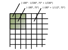
Figure 1: SPOT VGT 1 km Plate-Carrée Grid Cell
The SYN AOD product is provided on a super-pixel grid, created from OLCI image pixel. Each super-pixel is combined from 15 by 15 OLCI 300m pixels. The resolution is then equal to 4.5 km ².