Given that SYN products are computed from OLCI Level-1B and SLSTR Level-1B data (including nadir and oblique views), SYN swath coverage corresponds to the common part of the OLCI and SLSTR nadir view swaths for the daylight part of the SENTINEL-3 orbit, i.e. the entire OLCI swath: ~1 270 km (see figure below).
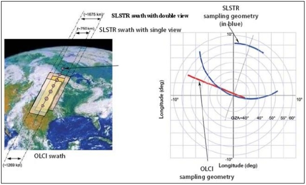
Figure 1: View of OLCI and SLSTR swath coverage and sampling geometry, in blue SLSTR oblique view (740 km) and nadir view (1 400 km), in red OLCI (1 270 km) (image credit: ESA)
As a result, the areas of the SLSTR nadir and oblique view Level-1B images not covered by the OLCI image, are rejected by cutting the images along-track and across-track. The daylight part of the orbit is defined for OLCI as the part of the orbit, where the sun zenith angle at satellite ground track is lower than 80°.
The VGP products cover latitude ranging from 56°S to 75°N (to be VEGETATION-like product).
The daylight part of the orbit is defined for OLCI as the part of the orbit where the sun zenith angle at satellite ground track is lower than 80°.
The mean global coverage revisit time is based on the longest revisit time of the two instruments, OLCI and SLSTR. It is less than 2 days at the equator with two operational satellites.