Radar data from Copernicus Sentinel-1 are supporting a bespoke monitoring service for cement operations, nuclear waste, mining and disaster management in Hungary.
Interferometric Synthetic Aperture Radar – or InSAR – is a technique using the phase of the radar signal, where two or more radar images over the same area combine to detect ground movement on the scale of millimetres. The method allows for consistent and high spatio-temporal resolution and coverage.
An InSAR-based Hungarian application platform, using radar data from the Copernicus Sentinel-1 mission of the EU’s Copernicus Programme, is providing customised space-borne displacement data services to various Hungarian industries.
Radar imagery from the mission is the backbone of InSAR4HU, an application platform developed by DATelite, an accelator company and spin-off from the University of Pécs.
The InSAR4HU service solution has been implemeted in Hungary since May 2023, with plans to expand over Central Europe (Czech Republic, Slovakia Austria, Serbia and Croatia). The expansion is aiming to be implemented in 2024 through specific partners, such as Premer Savkovic from Serbia, or international companies, such us Colas or Holcim.
InSAR helps track stability and safety of infrastructure
InSAR is particularly useful for detecting subtle changes in the ground, such as subsidence, deformation, and displacement, and can be used to provide insight into the stability and safety of infrastructure.
One key application area of InSAR4HU is helping to indicate potential structural issues in cement operations. Safety is paramount in cement production, and cement plants must comply with strict safety regulations and guidelines to ensure the safety of their workers and surrounding communities.
Cement plants consist of various types of equipment and infrastructure, such as storage warehouses and silos. These must be regularly inspected and maintained to ensure they are in good condition and free from any potential hazards or risks.
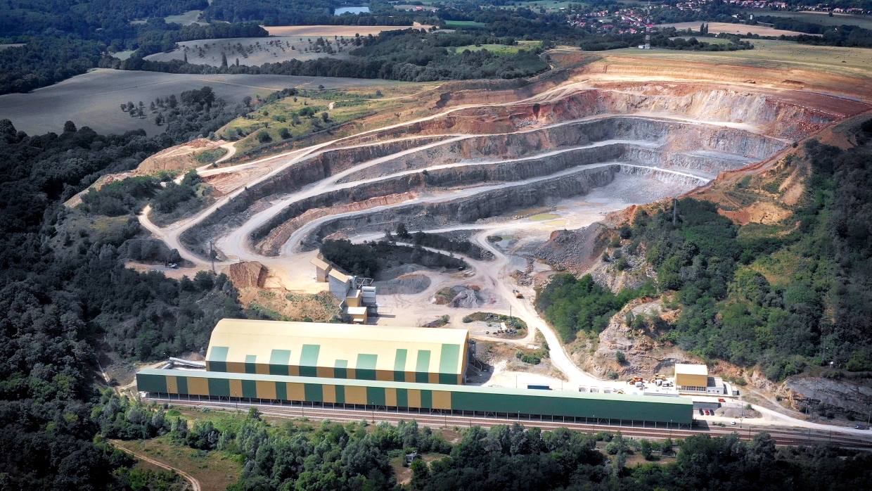
One of the major producers of cement for the Hungarian construction industry is Holcim Hungary Ltd. The company operates a modern manufacturing cement plant in Királyegyháza and a quarry in Bükkösd in Hungary.
Bükkösd cement extraction quarry is monitored for structural health using InSAR-based displacement measurements.
Copyright: Holcim
Holcim are using InSAR4HU via an operational dashboard showing displacement time series. InSAR-based displacement measurements monitor the cement plant and related quarry sites for the structural health of individual infrastructures, possible displacement of the areas surrounding the facility and the stability of (large) conveyor belts.
Additional use cases focus on the environmental effect of the cement plant on nearby settlements, such as damage detection caused by vibration (cement plant operations) and explosions (quarries).
Tamás Hoffmann, Country Manager of Holcim Hungary, says, “It was not evident how space technology could contribute to our operations, but with DATelite's technology we are able to extend the protocols for the routine monitoring of our key infrastructure, increasing our overall awareness and ultimately, the safety and security of our sites.”
InSAR dashboard helps monitor infrastructure safety in cement plants at Királyegyháza, Hungary
Copyright: Holcim
Management of nuclear waste protects the environment
The ESA-funded EO Science for Society project "InSAR Services for Key Hungarian Market Sectors", lead by DATelite, aims at achieving a broader use and adoption of InSAR in other industries in Hungary.
Uptake has focused on nuclear waste management, reclamation of former mining sites, and disaster prevention in relation to landslides. The management of radioactive waste, including continuous monitoring of the displacement of nuclear waste sites, is of great importance for Hungary’s energy and environmental safety.
In one application, more than 10,000 consumed fuel assemblies were placed in the Spent Fuel Interim Storage Facility at Paks. InSAR4Hu provides up-to-date data on their stability status and can provide operators with a clear indication of problems, using a solution mimicing traffic light signalling.
An operational InSAR application supports the work of the Hungarian Disaster Management Service (HDMS) by providing monthly monitoring of 63 water facilities, including 83 individual objects, distributed throughout Hungary [1].
InSAR4Hu can provide up-to-date data on the stability status of nuclear waste sites.
Copyright: Holcim
The potential of a nearly real-time warning system for water facility management was also demonstrated and HDMS is willing to make this warning system fully operational over the next few years. HDMS has also implemented InSAR solutions in a couple of use cases related to industrial safety and landslide detection.
In a follow-on ESA EO Science for Society activity, DATelite plan to target the structural health monitoring community by developing a best practice toolkit for implementing InSAR services.
About the Copernicus Sentinels
The Copernicus Sentinels are a fleet of dedicated EU-owned satellites, designed to deliver the wealth of data and imagery that are central to the European Union's Copernicus environmental programme.
The European Commission leads and coordinates this programme, to improve the management of the environment, safeguarding lives every day. ESA is in charge of the space component, responsible for developing the family of Copernicus Sentinel satellites on behalf of the European Union and ensuring the flow of data for the Copernicus services, while the operations of the Copernicus Sentinels have been entrusted to ESA and EUMETSAT.
Did you know that?
Earth observation data from the Copernicus Sentinel satellites are fed into the Copernicus Services. First launched in 2012 with the Land Monitoring and Emergency Management services, these services provide free and open support, in six different thematic areas.
The Copernicus Land Monitoring Service (CLMS) provides geographical information on land cover and its changes, land use, vegetation state, water cycle and Earth's surface energy variables to a broad range of users in Europe and across the World, in the field of environmental terrestrial applications.
It supports applications in a variety of domains such as spatial and urban planning, forest management, water management, agriculture and food security, nature conservation and restoration, rural development, ecosystem accounting and mitigation/adaptation to climate change.
References:
[1] Ronczyk, L. et al. ”Nationwide, Operational Sentinel-1 Based InSAR Monitoring System in the Cloud for Strategic Water Facilities in Hungary.” Remote Sens.;2022,14(14), 3251.
