Dormant since 1924, the Raikoke Volcano in the Kuril Island chain, near the Kamchatka Peninsula in Russia, recently awoke. Data from the Copernicus Sentinel-5P and Sentinel-3 satellites are giving vital information on its aftermath.
On 21 June at about 18:00 UTC, the circular 2.5 km x 2.0 km island discharged a vast plume of volcanic gases and ash, between 7 and 15 km into the sky. The thick plume was carried to the east by a cyclone in the North Pacific, which the Copernicus Sentinel-3 and Sentinel-5P satellites recorded.
Launched on 13 October 2017, Sentinel-5P is the first Copernicus satellite dedicated to monitoring our atmosphere. It is part of the fleet of Sentinel missions that ESA develops for the European Union's environmental monitoring Copernicus programme, managed by the European Commission.
The satellite carries the state-of-the-art TROPOMI instrument, which maps a multitude of trace gases such as nitrogen dioxide, ozone, formaldehyde, sulphur dioxide, methane, carbon monoxide and aerosols – all of which affect the air we breathe and therefore our health, and our climate.
Sulphur dioxide (SO2) emissions from volcanic eruptions can be a major natural hazard not only to the local environment and populations living near active volcanoes, but also to aviation. SO2 causes respiratory disease (e.g. when entering the aircraft cabin) as well as sulphidation of aircraft engines. Furthermore, SO2 can be a proxy for volcanic ash emissions, which can have a severe effect on aircrafts. As such, the timely provision of its measurements in case of volcanic eruptions is extremely important.
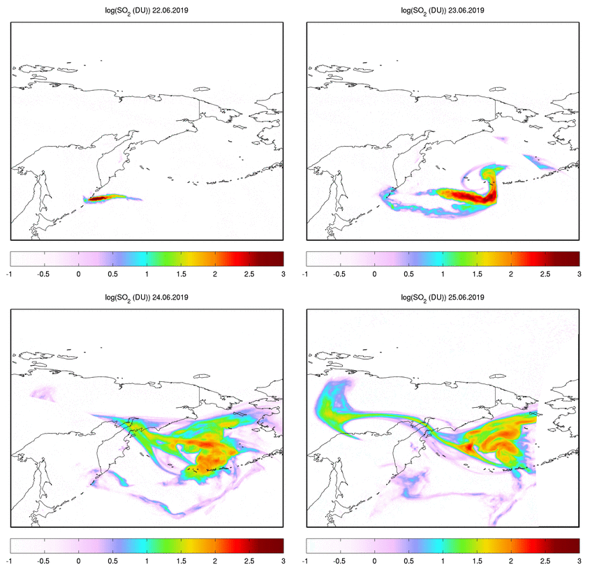
Nicolas Theys of BIRA-IASB, in charge of the Support to Aviation Control Service, comments, "The Copernicus Sentinel-5P satellite detected the sulphur dioxide emissions from the Raikoke eruption, showing the largest amounts of SO2 since the Nabro 2011 eruption."
The unprecedented spatial resolution of 3.5 × 7 km2 of the TROPOMI instrument aboard Copernicus Sentinel-5P makes it possible to detect these emissions like never before. The SO2 maps reveal fine details regarding the plume disperse in the atmosphere.
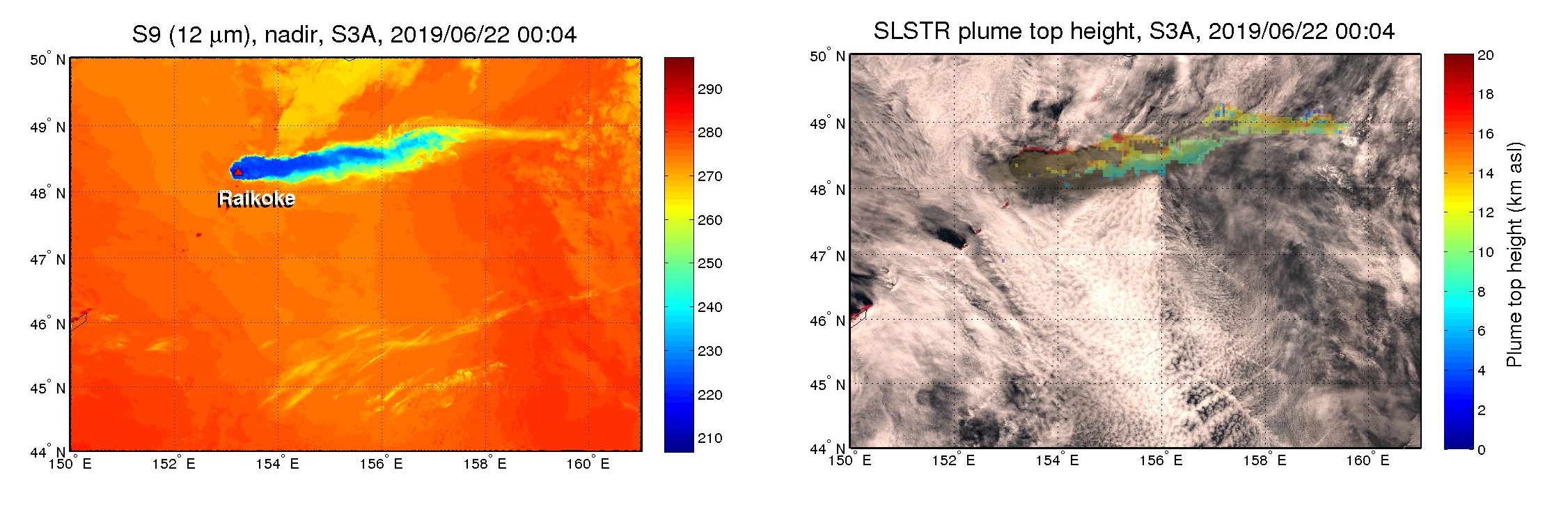
Raikoke also emitted great amounts of volcanic ash that was readily detected by the Copernicus Sentinel-3 Sea and Land Surface Temperature Radiometer (SLSTR).
The SLSTR instrument, designed for sea and land surface temperature monitoring, is also able to detect thick volcanic ash plumes using thermal infrared channels. SLSTR also has a unique dual view capability, which allows stereoscopic plume top height detection. The plume top height data complement information on the horizontal plume location, obtained from other satellite data.
"Using specific SLSTR algorithms (developed by the Finnish Meteorological Institute), it is not only possible to locate ash but also to determine the height of the plume. This information from Copernicus Sentinel-3 combined with Copernicus Sentinel-5P data gives a great picture of the situation and helps mitigate volcanic hazards for aviation", concluded Nicolas Theys.
About the Copernicus Sentinels
The Copernicus Sentinels are a fleet of dedicated EU-owned satellites, designed to deliver the wealth of data and imagery that are central to the European Union's Copernicus environmental programme.
The European Commission leads and coordinates this programme, to improve the management of the environment, safeguarding lives every day. ESA is in charge of the space component, responsible for developing the family of Copernicus Sentinel satellites on behalf of the European Union and ensuring the flow of data for the Copernicus services, while the operations of the Copernicus Sentinels have been entrusted to ESA and EUMETSAT.


