OLCI scans the Earth's surface using a push-broom method. CCD arrays provide spatial sampling in the across track direction, while the satellite's motion provides scanning in the along track direction. The instrument's 68.5° field of view, nadir pointing, covers a swath width of 1 270 km at altitude from SENTINEL-3 orbit (814.5 km). For the nominal orbit, at sub-satellite point, full spatial resolution (FR) of the OLCI instrument is approximately 300 m.
The SENTINEL-3 OLCI instrument has a 100% overlap with the SLSTR instrument swath.
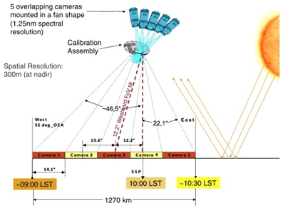
Figure 1:Basic geometry of the OLCI, showing the fan arrangement of the five cameras that will view Earth through the calibration assembly and the off-nadir pointing of the instrument swath. The Observation Zenith Angle (OZA) is limited to a maximum of 55°. The swath is 1 270 km. The Local Solar Time (LST) of observations is indicated in the lower part of the figure.
OLCI's field of view allows global coverage to be provided in 2-3 days, as required by oceanographic, land and atmospheric investigations.
| Constellation configuration | Revisit at equator | Revisit for latitude > 30° | Specification | |
|---|---|---|---|---|
| Ocean colour (sun-glint free, day only) |
1 satellite | < 3.8 days | < 2.8 days | < 2 days |
| 2 satellites | < 1.9 days | < 1.4 days | ||
| Land colour (day only) |
1 satellite | < 2.2 days | < 1.8 days | < 2 days |
| 2 satellites | < 1.1 days | < 0.9 days |
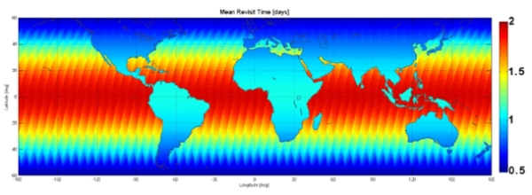
Figure 2: OLCI mean revisit time with a two-satellite configuration, in red 2 days are required to have revisit at equator, in blue less than 0.5 days at high latitude.