The Sea Surface Temperature (SST) measurement is obtained by means of a highly accurate calibration of the three infra-red channels at 3.74, 10.85 and 12 µm (S7-S8-S9) used for correction of the water vapour atmospheric absorption (split window during day and triple window during night) and observation of the same on-ground pixel by means of two atmospheric path views for correction of aerosol effects.
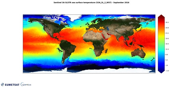
SST varies between -1.8°C, the temperature at which sea water freezes, and +30°C near/below the Equator, as seen in the global SST image below. Very high levels of accuracy and precision are required to support global climate monitoring and change detection. The SLSTR instrument and ground processing system are required to produce SST retrievals routinely from the corresponding brightness temperatures with an absolute accuracy of better than 0.3 K, globally, both for a single sample and when averaged over areas of 0.5° longitude by 0.5° latitude, under certain cloud-free conditions (i.e. >20% cloud-free samples within each area). The SLSTR instrument also has a temporal stability of 0.1 K/decade.

Global SST map (September 2016) derived from Sentinel-3A/SLSTR data. Sentinel-3 maintains and extends the high-quality SST measurements of the (A)ATSR series required by Copernicus and other climate services. (Credit: EUMETSAT)
It is important to note that SLSTR returns SST measurements for the ocean 'skin'. Due to the limited penetration of thermal infra-red radiation through the water column, the infra-red radiometric temperature is that of only the top few tens of micrometres. The temperature of the sea skin surface is typically a few tenths of a degree cooler than the temperature a few centimetres below. The oceanographically understood SST is a measure of the temperature in the top 10 cm.
Note also that the primary SLSTR Level-2 product provides SST following the Group for High Resolution Sea Surface Temperature (GHRSST) data processing specification. As a consequence, SST is given as a single field, derived from the best performing single-coefficient SST field in any given part of the swath.
For further information about the principles of measurements of the SLSTR, see the Technical Guide SLSTR Instrument Description.