Latest OLTC tables updates
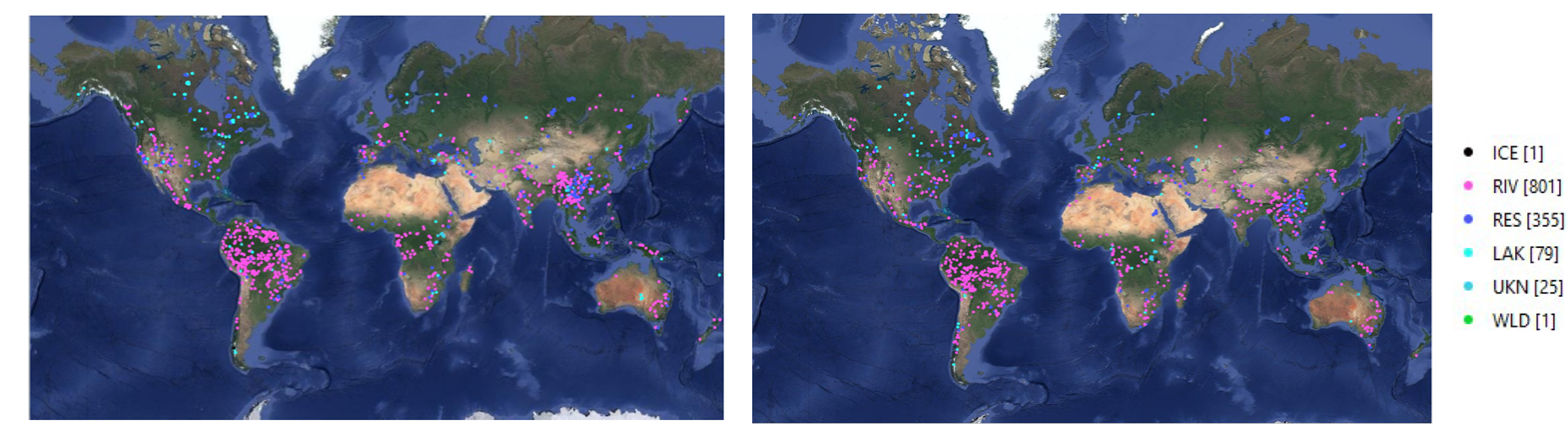
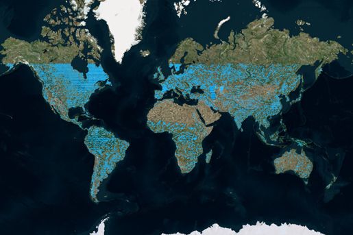
On 19 and 26 August 2021 the Sentinel-3B and Sentinel-3A OLTC tables have been respectively updated to version 3.1 and 6.1. These updates aim at improving the reference elevation of 1262 (Sentinel-3A) and 1153 (Sentinel-3B) hydrological targets whose locations are illustrated Figure 1.
Latest SRAL Mode Mask update
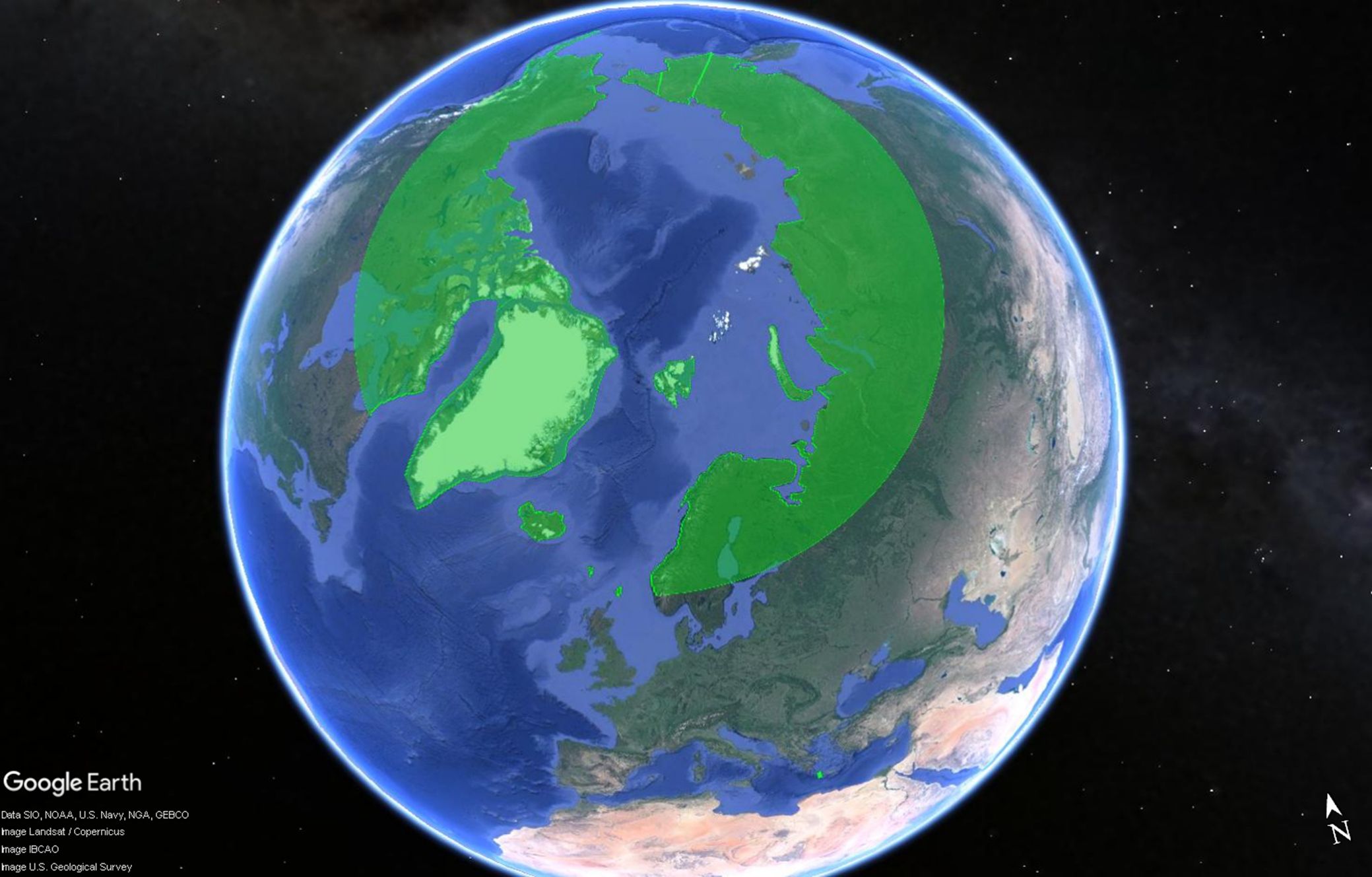
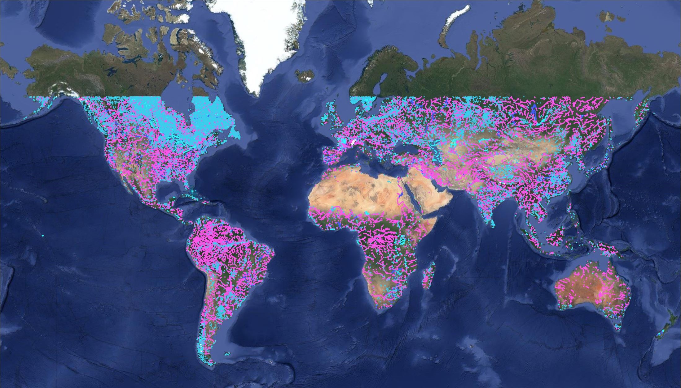
As result of the extension of the Open-Loop mode area related to the large improvements of the OLTC table version 6.0 (Sentinel-3A, on 7 November 2020) and version 3.0 (Sentinel-3B, on 10 October 2020) above 60° N latitude, the Close Loop mode area has been reduced, as presented in Figure 2.
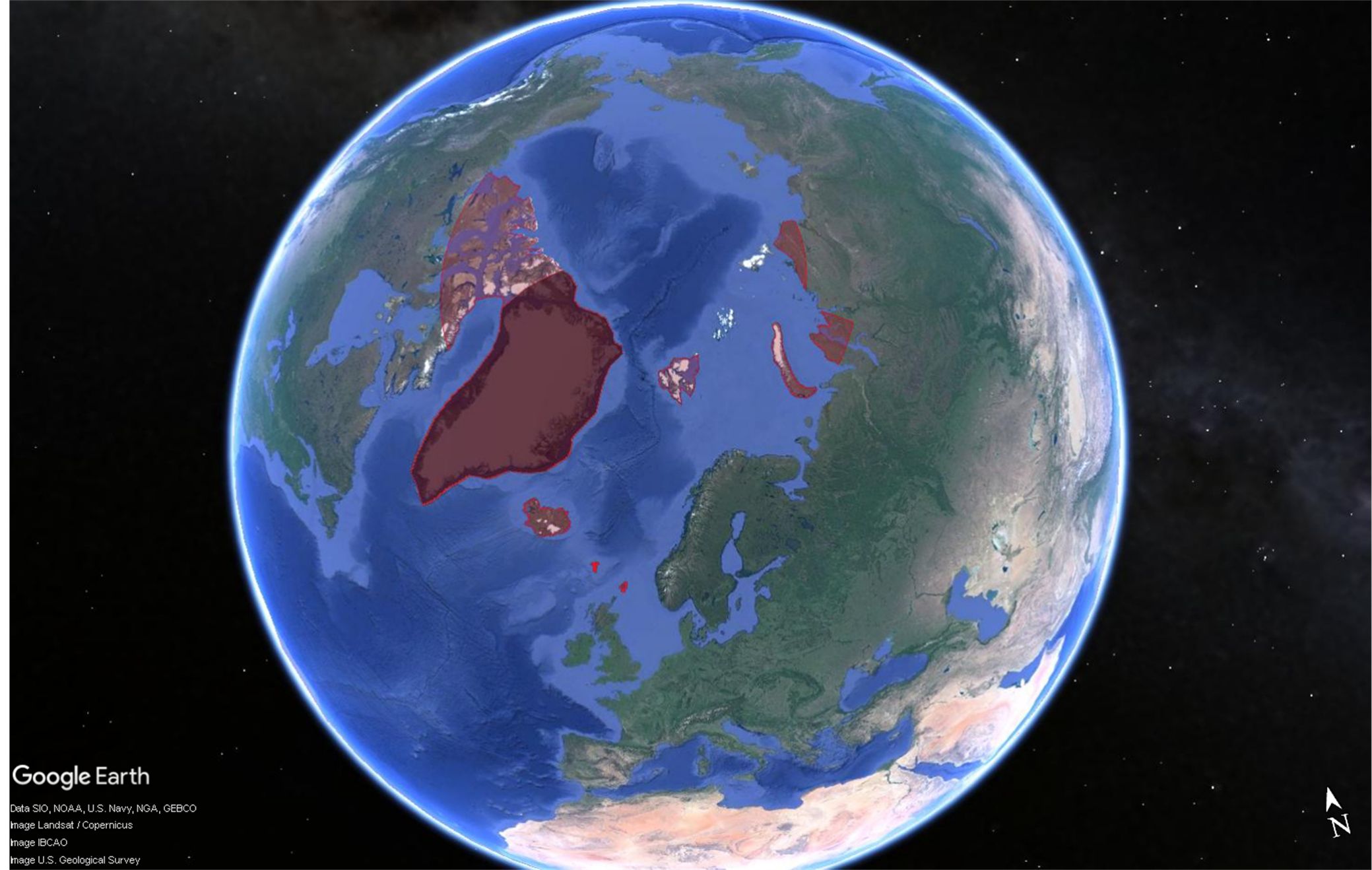
Note that in the South Hemisphere, the Close-loop areas around Antarctica remains unchanged.
OLTC Tables principle
Over the past decade, there has been a growing interest for altimetry measurements over inland waters. Studying the water levels of lakes, reservoirs and rivers is of prime importance for the hydrology community to assess the Earth's global resources of fresh water. In the context of the European Union's Copernicus Programme, Sentinel-3 altimeters are key to providing such global and continuous datasets of water surface height. Indeed, much progress has been made in the capability of altimeters to acquire quality measurements over inland waters. In particular, the Open-Loop Tracking Command (OLTC) represents a major evolution of the tracking function. This tracking mode's efficiency has been proven on past missions and it is now stated as operational mode on Sentinel-3 altimeters.
When operated in OLTC mode, the SRAL altimeter derives the distance between its antenna and the on-ground surface by combining the satellite altitude (Hs) provided by DIODE navigator of DORIS instrument with a given on-ground elevation information (H0) available in the OLTC tables (see Figure 3). The water surface height (Hw) can then be derived more “easily” through on-ground processing. The information coded in the OLTC is tuned over specific identified targets such as lakes, rivers, glaciers… elsewhere the information used might not be meaningful: Before the upload of OLTC version 6.0 for Sentinel-3A and version 3.0 for Sentinel-3B, (respectively updated in June 2020 and July 2020) this information was a prolongation of the last command specified. Now, the command over non-specific targets is optimized and derived from a Digital Elevation Model.
OLTC onboard tables are generated using software designed by CNES (F) and operated by NOVELTIS Company (F). This software merges elevation information from multiple sources (hydrological targets defined by users, global mean sea surface, local Digital Elevation Models) with satellite orbit reference file. The elevation information H0 is referenced with respect to the altimeter height reference (e.g. ellipsoid for Sentinel-3) and sampled every 1 km along the altimeter on-orbit position. For Sentinel-3A and Sentinel-3B, a supplementary optimization step is applied to reduce the size of OLTC tables due to limited on-board memory size: a limited number of segments of constant elevation are generated for each orbit. These OLTC tables are then uploaded in the dedicated on-board memory.

History of the OLTC table versions & SRAL acquisition mode mask modifications
OLTC tables
The OLTC tables are regularly updated in order to increase the number of specific identified targets (rivers, lakes, glaciers, etc.) as well as to improve and refine, when necessary, the command values over the already encoded targets. The following timeline shows the evolution of the OLTC table versions since the beginning of the Sentinel-3A & - 3B missions.

The same OLTC table (identified as version 4.2 for Sentinel-3A and version 1.0 for Sentinel-3B) was used for both satellites during the tandem phase. Once Sentinel-3B reached its final orbit on 27 November 2018, an updated OLTC table version 2.0 was activated. This version dedicated to the Sentinel-3B ground track was built with respect to an extended hydrological database compared to the previous version. A large number of the SRAL measurements over inland waters have been retrieved or improved. On 9 March 2019, the OLTC table was updated also for Sentinel-3A with version 5.0. As for Sentinel-3B, this OLTC table version includes a large number of new specific targets. Note that, at this occasion, the Sentinel-3A SRAL acquisition mode mask has been modified (see next paragraph). Figure 5, hereafter, gives an illustration of the number of inland waters specific targets considered in the OLTC table version 5.0 compared to the previous one, version 4.2.
On 18 June and 27 July 2020 the Sentinel-3B and Sentinel-3A OLTC table, respectively, were updated to version 3.0 and 6.0. As illustrated in Figure 6, the most important change introduced in this update is the densification of the identified specific targets (by more than a factor of 2) with notably an important number of new targets over rivers and lakes above 60° N.
In addition, and specifically for Sentinel-3A, new specific calibration sites have been identified as targets in the OLTC table version 6.0. Hereafter is the list of these sites:
- 12 glaciers over Antarctica (Victoria Land) to prepare future OLTC command dedicated to Land ice steepest areas.
- Catalina Island to prepare cross-comparison and calibration between Jason-3, Sentinel-6 and Sentinel-3A.
- Gavdos Island to prepare cross-comparison and calibration between Jason-3, Sentinel-6 and Sentinel-3A.
SRAL acquisition mode mask
On Sentinel-3, areas of interest (ocean and several land surfaces corresponding to the grey surfaces in Figure 7 and Figure 9) define where SRAL is operated in Open-Loop mode (use of the OLTC table command to drive the tracking window position). Outside these areas, SRAL altimeters operate in Close-Loop mode (a.k.a. autonomous tracking mode), with no a priori elevation information used to set the echo reception window.
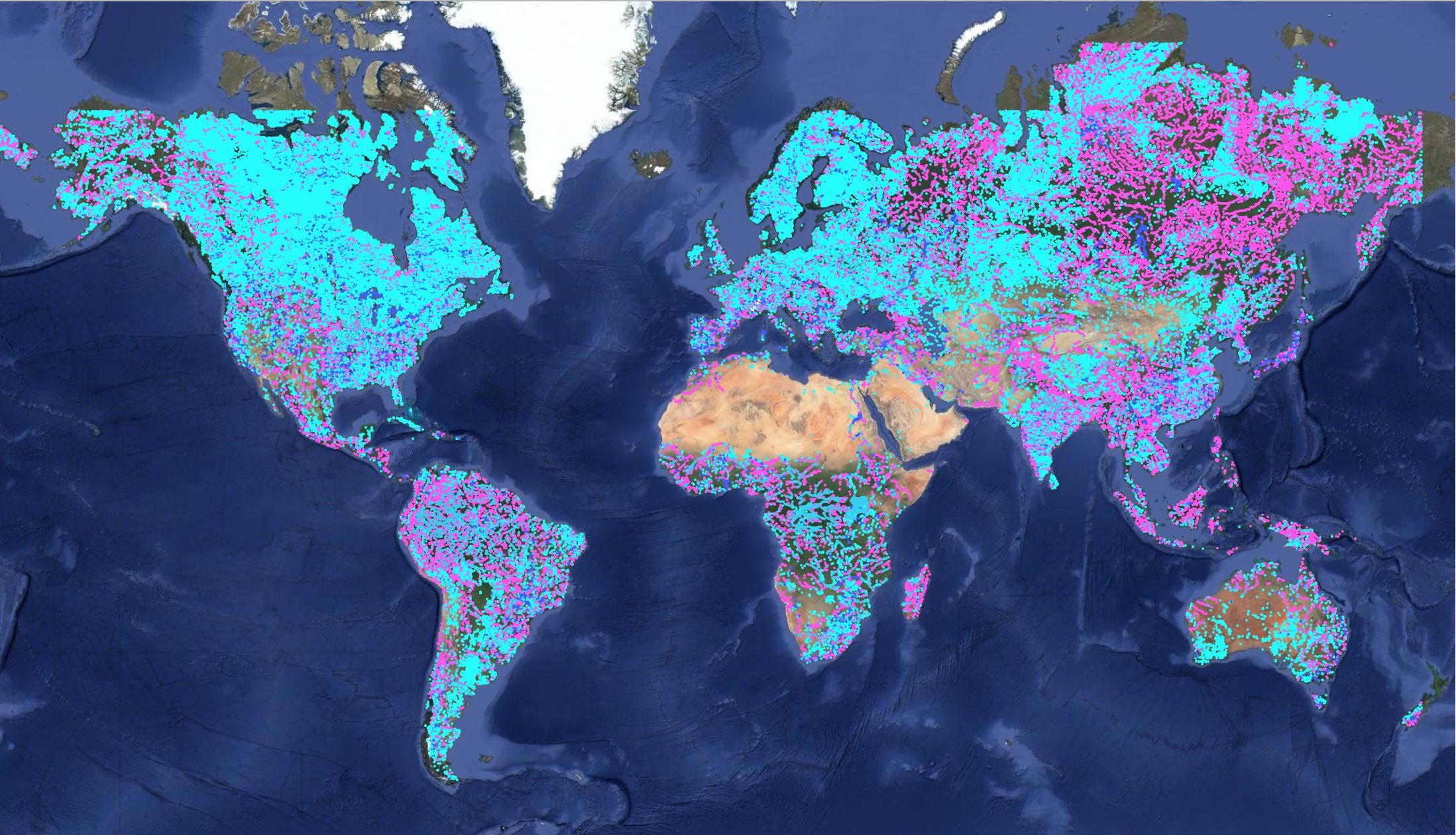
Sentinel-3A SRAL from its beginning of life until 9 March 2019 operated accordingly to the acquisition mode mask plotted in Figure 7. Only one modification occurred on 6 December 2016 to stop acquiring the Greenland and Antarctica ice sheet margins in Open-Loop mode as the OLTC commands over these steepest areas were not precise enough. This modification is illustrated in Figure 8.
From 9 March 2019 until 7 November 2020 Sentinel-3A SRAL operated accordingly to the same acquisition mode mask as the one defined for Sentinel-3B and represented in Figure 9. All the surfaces between 60° S and 60°N are acquired in Open Loop mode, above of below these limits, SRAL operate in Open-Loop mode over Ocean and in Close-Loop mode over Land.


Since its Beginning Of Mission (BOM) on 10 October 2020, the Sentinel-3B altimeter operated following the acquisition mode mask presented in Figure 8.

OLTC Tables and users' contributions
It is of high importance to define the most accurate and enriched contents of the OLTC onboard tables. For that matter ESA, together with its partners CNES and NOVELTIS, has developed a website for users to display and contribute to the OLTC contents: https://www.altimetry-hydro.eu

An interactive map allows visitors to view elevations defined onboard Sentinel-3 altimeters and navigate over inland water targets worldwide. Several visualization tools have been added to enhance the OLTC website experience: choice of map layout, display of satellite ground tracks and areas of interest.
Users wishing to further contribute to OLTC contents may sign up and have access to additional functionalities: once logged in, they have the possibility to submit modifications of existing elevations as well as requesting targets that may not yet be defined in the onboard OLTC tables. For example, adding a virtual station over a river or a lake, in order to enhance the OLTC contents and make sure that the altimeter will acquire quality echoes over the defined targets. Requests may be submitted directly using the “Contribute” tool or by sending a list of targets to the OLTC database management Committee.
Scientists and Sentinel-3 users may visit the website and contribute to the S3 OLTC content definition and enhance the SRAL altimeter’s measurement capability over inland waters and other suitable targets such as glaciers.
Illustration of the OLTC performance over Inland waters
Sentinel-3A OLTC tables were updated (to version 5.0) in March 2019. It consisted of:
- Increasing the number of targets over which an appropriate command of surface elevation is provided to the altimeter tracker
- Updating the a priori elevation encoded in the OLTC previous version. As presented on Figure 11, OLTC v5 presents an improvement with respect to v4.2 (compared over the same targets) as the number of observations with low backscatter coefficients has been drastically reduced (e.g. high backscatter coefficient values measured by the altimeter indicate that the measured surface is most probably water).
The improved distribution of the reflectivity (illustrated Figure 10) is an indication that the v5 tracking commands allow the altimeter to track water rather than other surfaces with lower reflectivity.

Figure 12 presents the time series of the backscatter coefficient values over one S3A intersection with river Mkuju. Vertical lines consist of high frequency (20 Hz) points over a same transect. Before the OLTC v5 update the coefficients where lower than 40 dB: the command did not allow the tracking of the water. Since March 2019, with the upload of OLTC v5, the coefficients present a drastic improvement and values are consistent with a signal related with water reflectivity.

Illustration of the OLTC performance over coastal areas
The following illustration (Figure 12) shows radargrams acquired by SRAL in Open-Loop or in Close-Loop in a coastal area. During the tandem phase, Sentinel-3B (right panel), during this period operated in Close-Loop mode at global scales. Between 48.90 and 48.95° of latitude, one can observe the impact of the land contamination, the leading edge is clearly moved to the right part of the tracking window, meaning that the instrument is tracking the wrong surface and needs some time to adjust its tracking to the ocean surface. On the contrary, for Sentinel-3A (left panel) the measurements were acquired in Open-Loop, a better stability of the energy in the tracking window is observed, especially for measurements located between the island and the continent.

