The Level-2A processing includes a Scene Classification and an Atmospheric Correction applied to Top-Of-Atmosphere (TOA) Level-1C orthoimage products. Level-2A main output is an orthoimage atmospherically corrected, Surface Reflectance product.
Please be aware that "Surface Reflectance (SR)" is a new term that has been introduced to replace the former one: "Bottom of Atmosphere (BOA) reflectance."
Additional outputs are an Aerosol Optical Thickness (AOT) map, a Water Vapour (WV) map and a Scene Classification (SCL) map together with Quality Indicators (QI) for cloud and snow probabilities at 60 m resolution. Level-2A output image products are resampled and generated with an equal spatial resolution for all bands (10 m, 20 m or 60 m). Standard distributed products contain the envelope of all resolutions in three distinct folders:
- 10 m: containing spectral bands 2, 3, 4 , 8, a True Colour Image (TCI) and an AOT and WVP maps resampled from 20 m.
- 20 m: containing spectral bands 1 - 7, the bands 8A, 11 and 12, a True Colour Image (TCI), a Scene Classification (SCL) map and an AOT and WVP map. The band B8 is omitted as B8A provides more precise spectral information.
- 60 m: containing all components of the 20 m product resampled to 60 m and additionally the bands 1 and 9, a True Colour Image (TCI), a Scene Classification (SCL) map and an AOT and WVP map. The cirrus band 10 is omitted, as it does not contain surface information.
The Sen2Cor [R1] processor algorithm is a combination of state-of-the-art techniques for performing atmospheric corrections which have been tailored to the SENTINEL-2 environment together with a scene classification module described in [R2].
The Scene Classification (SCL) algorithm allows the detection of clouds, snow and cloud shadows and generation of a classification map, which consists of three different classes for clouds (including cirrus), together with six different classifications for shadows, cloud shadows, vegetation, not vegetated, water and snow. Cloud screening is applied to the data in order to retrieve accurate atmospheric and surface parameters during the atmospheric correction step. The L2A SCL map can also be a valuable input for further processing steps or data analysis.
The SCL algorithm uses the reflective properties of scene features to establish the presence or absence of clouds in a scene. It is based on a series of threshold tests that use as input: TOA reflectance of several SENTINEL-2 spectral bands, band ratios and indexes like Normalised Difference Vegetation Index (NDVI) and Normalised Difference Snow and Ice Index (NDSI). For each of these threshold tests, a level of confidence is associated. It produces at the end of the processing chain a probabilistic cloud mask quality indicator and a snow mask quality indicator. The most recent version of the SCL algorithm includes also morphological operations, usage of auxiliary data like Digital Elevation Model and Land Cover information and exploit the parallax characteristics of SentinelSENTINEL-2 MSI instrument to improve its overall classification accuracy.
The aerosol type and visibility or optical thickness of the atmosphere is derived using the Dense Dark Vegetation (DDV) algorithm [R3]. This algorithm requires that the scene contains reference areas of known reflectance behaviour, preferably DDV and water bodies. The algorithm starts with a user-defined visibility (default: 40 km).
If there are not enough DDV-pixels present in the image, then the aerosol optical depth estimates present in the CAMS auxiliary file (embedded in L1C and L2A products) are used to derive the visibility of the atmosphere.
Water vapour retrieval over land is performed with the Atmospheric Pre-corrected Differential Absorption (APDA) algorithm [R4] which is applied to the two SENTINEL-2 bands (B8a, and B9). Band 8a is the reference channel in an atmospheric window region. Band 9 is the measurement channel in the absorption region. The absorption depth is evaluated in the way that the radiance is calculated for an atmosphere with no water vapour assuming that the surface reflectance for the measurement channel is the same as for the reference channel. The absorption depth is then a measure of the water vapour column content.
Atmospheric correction is performed using a set of look-up tables generated via libRadtran. Baseline processing is the rural/continental aerosol type. Other look-up tables can also be used according to the scene geographic location and climatology.
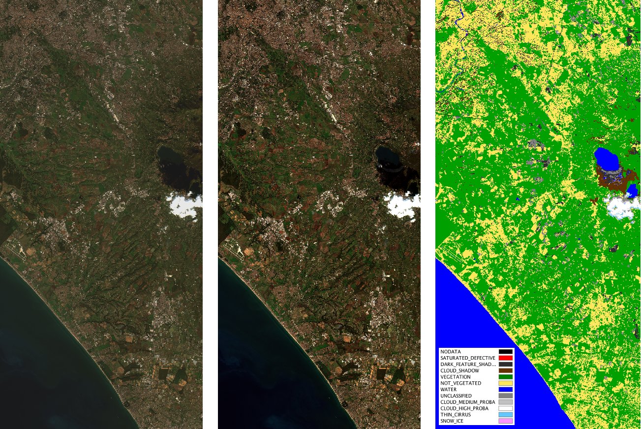
The figure shows from left to right: (1) SENTINEL-2 Level-1C TOA reflectance input image, (2) the atmospherically corrected Level-2A Surface Reflectance image, (3) the output Scene Classification map of the Level-1C product.
[R1]: M. Main-Knorn, B. Pflug, J. Louis, V. Debaecker, U. Müller-Wilm, F. Gascon, "Sen2Cor for Sentinel-2", Proc. SPIE 10427, Image and Signal Processing for Remote Sensing XXIII, 1042704 (2017)
[R2]: Sentinel-2 Level-2A ATBD
[R3]: Kaufman, Y., Sendra, C. Algorithm for automatic atmospheric corrections to visible and near-IR satellite imagery, International Journal of Remote Sensing, Volume 9, Issue 8, 1357-1381 (1988)
[R4]: Schläpfer, D. et al., "Atmospheric precorrected differential absorption technique to retrieve columnar water vapour", Remote Sens. Environ., Vol. 65, 353366 (1998)