A new processing tool has been developed to bundle information contained in large amounts of satellite data, paving the way for the wealth of Copernicus Sentinel satellite data to be more easily incorporated into online environment-monitoring services.
A new processing tool has been developed to bundle information contained in large amounts of satellite data, paving the way for the wealth of Copernicus Sentinel satellite data to be more easily incorporated into online environment-monitoring services.
ESA's online Urban Thematic Exploitation Platform (U-TEP) makes information from satellite data available for the non-expert user for urban environment monitoring.
To do this, it processes hundreds of terabytes of data gathered by Earth-observing satellites, and translates them into easy-to-use products for scientists, urban planners and decision-makers.
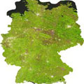
U-TEP reached a milestone recently with the integration of some 450 000 scenes from the US Landsat-8 mission acquired between 2013 and 2015. The 500 TB was reduced to about 25 TB thanks to the TimeScan processor developed by the DLR German Aerospace Center. The resulting TimeScan Landsat 2015 product is already available on the U-TEP geobrowser.
