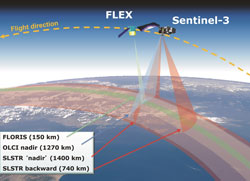
ESA's Fluorescence Explorer (FLEX) mission will orbit in tandem with one of the Copernicus constellation satellites. Taking advantage of Sentinel-3's optical and thermal sensors will lead to an integrated package of measurements to assess plant health. With the Sentinel-2 satellites also in orbit, there is a unique opportunity of using this data synergistically from all three missions for vegetation studies.
ESA's Fluorescence Explorer (FLEX) mission will orbit in tandem with one of the Copernicus constellation satellites. Taking advantage of Sentinel-3's optical and thermal sensors will lead to an integrated package of measurements to assess plant health. With the Sentinel-2 satellites also in orbit, there is a unique opportunity of using this data synergistically from all three missions for vegetation studies.
ESA's eighth Earth Explorer mission, FLEX, was selected for implementation in 2015 to provide information on the terrestrial vegetation layer and plant health.
During the week of 17-19 January, the Remote Sensing of Fluorescence, Photosynthesis and Vegetation Status workshop took place at ESA's ESRIN facility in Frascati, Italy.
During the workshop, scientists further examined how the Copernicus Sentinel missions and FLEX could work together to provide unprecedented combinations of spatial resolution, temporal revisit time and spectral coverage that would lead to a wide range of opportunities for novel datasets and applications.
With an organising team made up of ESA's Sentinel-2 and Sentinel-3 mission managers, the FLEX mission scientist and data-quality experts along with a scientific committee comprising experts from varied institutions worldwide, the workshop brought together remote-sensing experts and potential users. They explored new synergistic Earth observation capabilities that could be provided by the FLEX, Sentinel-2 and Sentinel-3 missions.
The emphasis was on the connection between two types of Earth observation missions: Earth Explorers and the Copernicus Sentinels, where ESA has a lead role in monitoring vegetation-relevant parameters over land.
The useful interaction between new measurements that come from a 'first' like FLEX and sensors already in orbit combine scientific and operational expertise, providing a feedback for the evolution of data products.
Susanne Mecklenburg, ESA's Sentinel-3 Mission Manager, emphasised, "It is very exciting to see how data from these mission could be used in synergy. The value that a synergistic approach, using information from different sensors, can add to our understanding of a particular topic - in this case for monitoring vegetation for agricultural applications - but also for our general understanding of how these parameters describe a rather complex biosphere system."
The thematic (rather than mission) focussed approach of the workshop directly responded to the needs of the user community, aiming at combining the best-available information based on a variety of sensors in their respective applications.
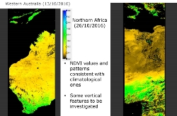
The Copernicus Sentinel-3A satellite, almost one year in orbit, is now starting to produce higher level products, based on the already-released OLCI and SLSTR Level-1 data. Claire Henocq from ACRI-ST explained the current work in developing these vegetation-relevant products.
"Vegetation-relevant products are provided through a SYNERGY processing chain part of the Ground Segment of the Copernicus Space Component. This complex algorithm has been designed to fulfil two main requirements.
"Firstly, that of providing surface vegetation products derived from synergistic and co-located radiometric measurements from the OLCI/SLSTR instruments. Thanks to the wider spectral range and multiple-angular views, an aerosol retrieval module can be performed.
"Secondly, ensuring the continuity of SPOT VEGETATION missions.
"The on-going validation of the SYNERGY processing chain and SYNERGY-VGT-like products (in particular in comparison to other vegetation products), will provide important knowledge on geometric co-registration and synergistic exploitation of two different instruments, on the combination of different spectral ranges, and more specifically on data complementarity, to enlarge the temporal range of land products."
Sentinel-2B is planned for liftoff on 7 March, completing the two-satellite mission. This configuration will optimise coverage and global revisit times: revisit at the equator is reduced to five days with two satellites, which will result in an even faster revisit at higher latitudes.
The workshop also provided updates on recent modelling activities coupling remote-sensing signals and vegetation physiology and dynamics, as well as planning future activities in the field of remote sensing, exploring new observational activities.
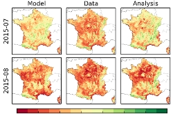
Jean-Christophe Calvet, researcher at CNRM (Meteo France, CNRS) and head of a research section focusing on land remote-sensing and modelling, showed the effects of using vegetation-relevant parameters such as Leaf Area Index (LAI) in a Land Data Assimilation System (LDAS).
"The LDAS is able to sequentially integrate satellite observations into the Interactions between Soil, Biosphere, and Atmosphere (ISBA) land surface model of the SURFEX modelling platform. The simulated vegetation biomass and LAI are updated, as soon as new LAI observations are available.
"This is a powerful tool for monitoring droughts. Reference in-situ observations of the agricultural yields of straw cereals over France show that by using satellite data a significant correlation between the maximum annual above-ground biomass simulated by ISBA and the agricultural yield at the scale of administrative units can be achieved.
"Without satellite data, very low correlations are observed. It is also shown that new 10-day drought indicators, complementary to soil moisture, can be derived from the LAI and from the above-ground biomass of vegetation. The LDAS is now able to work at a global scale (LDAS-Monde).
"It will gradually evolve towards finer spatial scales and will be progressively upgraded to sequentially assimilate fluorescence observations," concluded Dr Calvet.
The Sentinel-3 mission is also based on a pair of satellites, both orbiting Earth at an altitude of 814.5 km. This configuration optimises spatial and temporal coverage and, thus, global revisit. For the optical instruments, OLCI and SLSTR, the two satellites will provide global coverage every two to three days. The data will be acquired and processed systematically and available for users within 3–48 hours after sensing, depending on the data product and application.
Each satellite is designed for a life of at least seven years and has enough fuel to provide up to 12 years of continuous operations, producing continuity, long-term monitoring, and further benefit to various operational applications.
Together with the rest of the Copernicus Sentinel fleet, these missions will make a unique contribution to the quality and quantity of Earth observation measurements over our planet.
About the Sentinels
The Sentinels are a fleet of dedicated EU-owned satellites, designed to deliver the wealth of data and imagery that are central to Europe's Copernicus environmental programme.
In partnership with EU Member States, the European Commission leads and coordinates this programme, to improve the management of the environment, safeguarding lives every day. ESA is in charge of the space component, responsible for developing the family of Copernicus Sentinel satellites and ensuring the flow of data for the Copernicus services, while the operations of the Sentinels have been entrusted to ESA and EUMETSAT.


