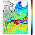
Following the first impressive images from Sentinel-3A, this latest Copernicus satellite is now showing us how another of its instruments, an altimeter, will track sea-level change.
Following the first impressive images from Sentinel-3A, this latest Copernicus satellite is now showing us how another of its instruments, an altimeter, will track sea-level change.
Just after the radar altimeter instrument was turned on, it traced the height of the sea surface over a stretch of the North Atlantic, some of the most dynamic ocean waters in the world.
Showing features relating to the Gulf Stream, the track compares very well with the background map of sea-surface height.
The map, produced by the Copernicus Marine Environment Monitoring Service, comprises near-realtime data for one day from the CryoSat, Jason-2 and SARAL/AltiKa satellites.
The altimeter is designed to deliver accurate measurements of sea-surface height, significant wave height and surface-wind speeds over the world's oceans for Copernicus ocean forecasting systems and for monitoring sea-level change.
