Observations derived from Synthetic Aperture Radar imagery show that wave stresses—which can be highly variable—are important external forces on sea ice within a few hundred kilometres of the ice edge.
Observations derived from Synthetic Aperture Radar imagery show that wave stresses—which can be highly variable—are important external forces on sea ice within a few hundred kilometres of the ice edge.
Southern Ocean sea ice plays a key role in regulating the uptake of carbon and heat by the global ocean. It is known that waves impact the sea ice, including ice break-up and pancake-ice formation. These processes explain large differences in sea ice properties between the Arctic and Antarctic.
Ocean waves also impact sea ice by exerting a force in their propagation direction that compacts the ice. To date, this external forcing has not been quantifiable due to lack of large-scale observations.
Researchers from the Laboratory of Ocean Physics and Satellite remote sensing (LOPS) in France explored and quantified this external wave to sea ice in a paper entitled "Strong and highly variable push of ocean wave on the Southern Ocean sea ice" recently published in the Proceedings of the National Academy of Science of the United States of America (PNAS).
Since 1978, satellite-based Synthetic Aperture Radar (SAR) imagery has been used to study wave–ice interaction starting with SeaSat and with the European remote sensing satellite ERS-2. The new, higher resolution Sentinel-1 SAR images motivated further analysis of wave in ice patterns, leading to a quantitative estimation method for the directional wave spectrum, from which wave heights, periods and directions can be derived.
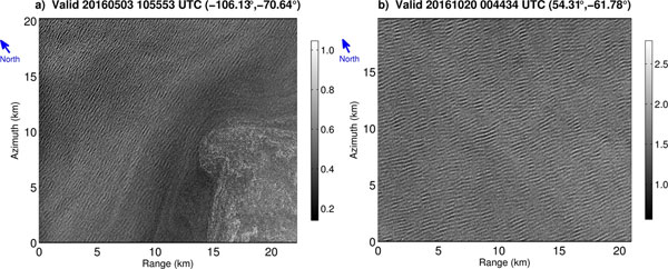
The European Union's Copernicus Sentinel-1 satellite operates over most of the oceans in a 4 m resolution "wave mode", designed to monitor ocean waves. The wave mode provides 20 x 20 km images every 100 km along the satellite orbit, revealing stunning details of air–sea interaction processes including waves propagating underneath sea ice, as shown in the images.
Soon after launch in 2014, the Sentinel-1A acquisition cycle was modified to extend wave-mode coverage over Antarctic Sea ice. In 2016, Sentinel-1A was followed by its twin Sentinel-1B.
The Copernicus Sentinel-1A and -1B satellites combined with the new method to extract wave information from the imagery, make it possible for remote sensing and wave-mechanic experts to extract thousands of observations across the entire Antarctic marginal ice zone and for all seasons.
This dataset of wave conditions in sea ice is larger than all other field experiments combined and is expected to contain a wide range of sea ice conditions demonstrating the advantage of using satellites to study remote polar regions.
Experts find that the wave decay can be much faster than previously reported. More importantly, such decay is highly variable spanning three orders of magnitude. Particular radar images show drastic wave decay much larger than previously observed.
Therefore, the off-ice wave conditions do not determine the wave attenuation for the entire journey of a wave packet in sea ice. This means the same wave train can experience a weak attenuation over hundreds of kilometres and suddenly disappear over just a few kilometres.
Justin Stopa, ocean wave expert and lead author of the study published in PNAS, explains that, "The Southern Ocean is one of the most active regions of the global ocean and the persistent wave action directed into the Antarctic marginal ice zone is an important external forcing.
"This was demonstrated by comparing average wave stresses to the often dominant wind stresses over large areas of the Antarctic marginal ice zone, suggesting that wave forcing has a profound impact on both ice extent and thickness."
Information about ocean waves from Sentinel-1 complements data from Sentinel-3, further helping the Copernicus Marine Service to monitor different marginal ice zones.
About the Sentinels
The Sentinels are a fleet of dedicated EU-owned satellites, designed to deliver the wealth of data and imagery that are central to Europe's Copernicus environmental programme.
In partnership with EU Member States, the European Commission leads and coordinates this programme, to improve the management of the environment, safeguarding lives every day. ESA is in charge of the space component, responsible for developing the family of Copernicus Sentinel satellites and ensuring the flow of data for the Copernicus services, while the operations of the Sentinels have been entrusted to ESA and EUMETSAT.
