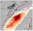
In this study the team use geodetic data to determine surface deformation associated with the Mw 5.1 earthquake that occurred in Lorca, southeast Spain, on 11 May 2011.
In this study the team use geodetic data to determine surface deformation associated with the Mw 5.1 earthquake that occurred in Lorca, southeast Spain, on 11 May 2011.
To constrain the coseismic slip, surface deformation was measured by radar interferometry. In addition, available GPS data were processed both at daily and at 1 Hz rates to determinate static and transient offsets. Two different Envisat ASAR descending satellite tracks (I2 and I6) imaged the area before and after the event, providing estimates of the displacements field from two different look angles. Differential interferograms were processed in time series without temporal filtering and resulting displacement maps were corrected for a known groundwater-extraction subsidence signal.
