The monitoring of frozen river break-ups at high latitudes is a daunting task, where hazards such as flooding and infrastructure damage can occur in mere days and are difficult to forecast— the monitoring from space of how river ice break-ups unfold and progress could help mitigation efforts, create data for reanalysis and aid hazard assessments.
The monitoring of frozen river break-ups at high latitudes is a daunting task, where hazards such as flooding and infrastructure damage can occur in mere days and are difficult to forecast— the monitoring from space of how river ice break-ups unfold and progress could help mitigation efforts, create data for reanalysis and aid hazard assessments.
Researchers from the University of Oslo have demonstrated the feasibility of such a spaceborne system, by simply combining data from pre-existing satellites with those of the current Sentinel-2 satellites of the European Union's Copernicus Programme.
Every year when spring arrives, snow from the previous winter starts to melt. This meltwater finds its way through the snowpack, accumulating in creeks and rivers. However, these rivers are still covered by ice, which also tends to melt. While more and more meltwater is delivered to the rivers, the water pressure under the ice cover increases. Similarly, on top of the ice cover the snow and ice layer slowly melt, becoming thinner. Eventually, the water pressure can be of such magnitude that it is able to crack the ice, resulting in a river ice break-up. The ice cover separates into large chunks and drifts along with the river, forming a front of water, ice and rubble.
Broken river ice can progress as a rapid and intense front, causing damage to infrastructure and possibly resulting in local flooding. Particularly in the Arctic, where spring arrives later, these break-up events occur on an annual basis, as most Arctic rivers flow northwards. Monitoring of the progression of such break-up events is challenging, as these rivers are several hundreds of kilometres long, and the clearance of ice cover can occur within a week's time.
Earth observation satellites are ideal for this application, since they observe large parts of the globe, with ever increasing coverage. When near-simultaneous acquisitions of optical satellites imagery are analysed, the movement of the ice-floes can be measured. However, not many satellites record imagery with a time delay of mere seconds.
Researchers from the University of Oslo tried to combine data from several optical satellite systems to find the best monitoring solution. While not preconceived, many of these satellites fly closely in similar sun-synchronous orbits, enabling the satellites to observe Earth's targets with a constant local solar time.
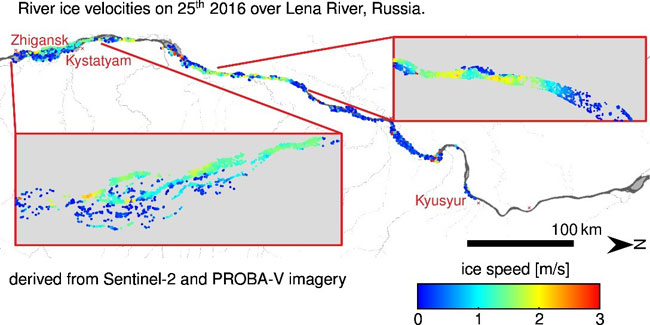
More so in polar regions, the recording is done almost simultaneously. This property is not exploited to its fullest potential, as many satellites generate products based upon their own instrument setup. The research from Oslo demonstrated that this data fusion can be done with imagery from Copernicus Sentinel-2 and PROBA-V satellites.
Bas Altena, currently researcher at Utrecht University, states, “We were already able to measure river ice velocities with high-resolution satellite data, which deliver users with detailed views of river ice processes. But now we showed this extraction of velocity data can also be done with medium and even coarse resolution satellites, like PROBA-V.
"Another bottleneck for upscaling this application to an operational service, is the computational time, but by using coarse resolution data this is reduced significantly, making large scale processing possible," continued Dr Altena.
In order to do so, the team of researchers did have to implement additional filtering steps, to reach an efficient river ice tracking pipeline. The final implementation is being able to compute detailed velocities over several hundreds of kilometres of a river.
Their study demonstrates the potential of an integrated view of information, generated from multiple satellites. Such approaches do not stand on their own, since in recent years more coordination has been established between satellite programmes and space agencies. For instance, the orbit of ESA's CryoSat satellite was recently adjusted, so it has more frequent near-simultaneous overpasses with NASA's ICESat-2 satellite at high latitudes.
The different instruments on these advanced RADAR and LIDAR satellites, make the extraction of advanced products feasible. While the above-mentioned resonant orbits are intended, this is not the case for Copernicus Sentinel-2 and PROBA-V. Both satellites have optical instruments onboard, but at different resolutions. However, by combining data from both, the researchers were able to extract river ice displacements.
"Who knows what other combinations are possible—combining satellite data from multiple satellites create products, but this relation does not add up, it multiplies itself," concludes Bas Altena.
About the Copernicus Sentinels
The Copernicus Sentinels are a fleet of dedicated EU-owned satellites, designed to deliver the wealth of data and imagery that are central to the European Union's Copernicus environmental programme.
The European Commission leads and coordinates this programme, to improve the management of the environment, safeguarding lives every day. ESA is in charge of the space component, responsible for developing the family of Copernicus Sentinel satellites on behalf of the European Union and ensuring the flow of data for the Copernicus services, while the operations of the Copernicus Sentinels have been entrusted to ESA and EUMETSAT.
About PROBA-Vegetation
PROBA-V is an ESA EO mission, initiated by the Belgian Science Policy Office (BELSPO).
The mission was originally conceived to fill the monitoring gap between recordings from the SPOT legacy satellites and the twin constellation of Copernicus Sentinel-3A and -3B. The satellite was launched in May 2013, somewhat before the end-of-life was declared for the SPOT-5 satellite in March 2015, and prior to the launch of Copernicus Sentinel-3A in February 2016.
The recording overlap between both missions enabled the continuation of time-series regarding vegetation cover. As of July 2020, PROBA-V ended its operational phase and moved into its experimental phase, where it will be accompanied by two cube-sats.
About The Living Planet Fellowship
The Living Planet Fellowship is an ESA initiative, supporting the new generation of scientists within ESA's Member States, to undertake cutting-edge research in Earth Observation and advance Earth system science.
This article reflects the research that was made possible through an ESA Living Planet Fellowship awarded to Bas Altena.
For more information visit the EO4Society website


