The Magra reservoir in Alentejo, Portugal, became the test site for Aquatic Ecosystem Analysis students, learning to use remote sensing to monitor and possibly forecast algae blooms.
The Magra reservoir in Alentejo, Portugal, became the test site for Aquatic Ecosystem Analysis students, learning to use remote sensing to monitor and possibly forecast algae blooms.
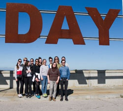
Last February, The Polytechnic Institute of Beja, Portugal, organised an international field work (IFW) event on the topic of Hyperspectral Imaging (HSI)/Multispectral Imaging (MSI) for monitoring water quality in lakes. Part of a collaboration that has been ongoing since 2016, with AERES University, NL, this year it included students from The Netherlands, Belgium, Poland, and Croatia.
The workshops and the student's work were based on products from the Sentinel-2 satellites of the European Union's Copernicus Programme, to plan an early warning system for algae blooms.
The IFW programme included speakers from the Portuguese Space Agency, SpaceLayer Technologies—a Portuguese start-up company and Copernicus Academy that participates in European Space Agency Business Incubation Centre in Coimbra, Portugal, and researchers from HyperComp, the HSI computing research group from the Extremadura University.
It lasted five weeks and featured three workshops: (i) HSI Principles & Applications, (ii) HSI for Water Quality Monitoring, (iii) Copernicus Sentinel-2 Product Processing using the Sentinel Hub.
In this fourth edition, it was decided that the solution should integrate HSI/MSI using data from the Copernicus Sentinel-2 satellites, to implement an early warning system for algae blooms.
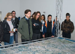
Water from the Magra reservoir is used for agriculture and (after treatment) for human consumption. The students visited the reservoir and the water treatment plant so that they could experience the site in person and have a meeting with the stakeholders to understand the major problems they have encountered.
Every week, the students (two teams of four and five students of mixed nationalities) gave a presentation to show the evolution of their solution to the problem. At the end of the IFW, each team presented their final solution for algae blooms: how to use Copernicus Sentinel-2 products to create an early warning system and how to mitigate the algae bloom with in situ measures.
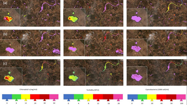
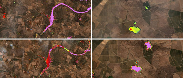
During the workshop, students understood how HSI/MSI remote sensing can be used for water quality monitoring, complementing in situ data in an efficient and inexpensive way. This is particularly important when studying large water bodies. Using Copernicus Sentinel-2 products (L1C and L2A) and custom scripts, they generated maps for the spatial distribution of relevant parameters to assess the water quality, such as, chlorophyll a, cyanobacteria, turbidity, coloured dissolved organic matter, dissolved organic carbon, and colour.
Most importantly, both teams were able to use the procedures they learned in the case study, to correlate the algae blooms in Magra with events on another reservoir of the system, and propose an early warning system based on this correlation (as shown in the following images).
The IFW had three main learning objectives: the students should be able to (i) work in an interdisciplinary and international context, (ii) develop a relationship with the stakeholders and understand their problem, and finally (iii) develop a comprehensive solution.
In addition, they acquired important soft skills during the work, while applying their scientific and technical know-how.
Dr Nuno Pereira, Professor at the Polytechnic Institute of Beja, comments, "This proved to be a good decision as it was clear that students with no background in remote sensing, HSI, or script programming are able to use satellite products to develop a solution for a real-world problem. From the point of view of the organising commission, this was a success, and the next edition is already on it way!"
About the Copernicus Sentinels
The Copernicus Sentinels are a fleet of dedicated EU-owned satellites, designed to deliver the wealth of data and imagery that are central to the European Union's Copernicus environmental programme.
The European Commission leads and coordinates this programme, to improve the management of the environment, safeguarding lives every day. ESA is in charge of the space component, responsible for developing the family of Copernicus Sentinel satellites on behalf of the European Union and ensuring the flow of data for the Copernicus services, while the operations of the Copernicus Sentinels have been entrusted to ESA and EUMETSAT.
Acknowledgements: The IFW Organising Commission includes: Fátima Carvalho (Coord.), Nuno Pereira, Fernanda Pereira, Anabela Durão, Polytechnic Institute of Beja – Portugal and Annet Pouw, AERES University of Applied Sciences Almere – Netherlands


