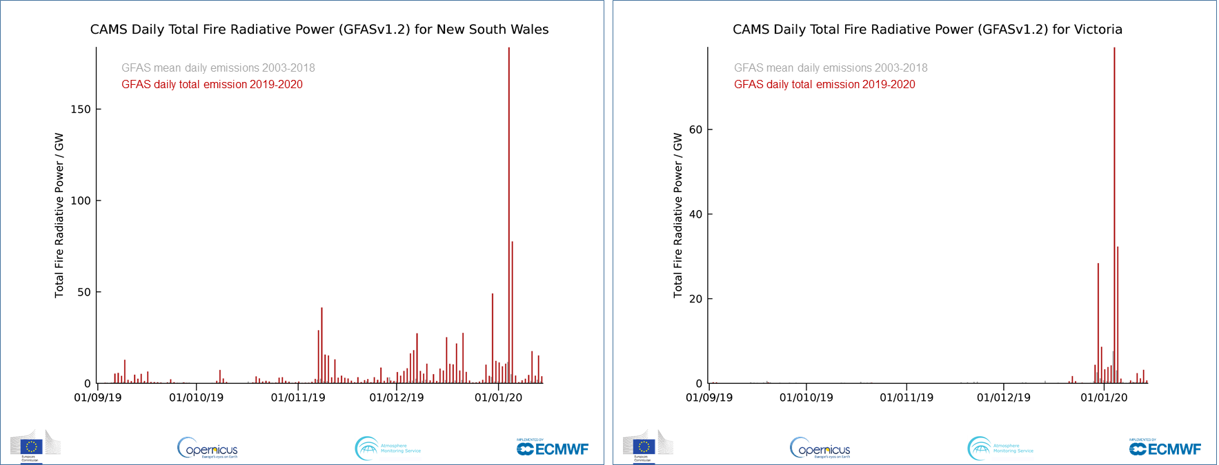
A recent study was carried out comparing NASA's FIRMS data with Copernicus Sentinel data, resulting in Copernicus Sentinel-1 data particularly detecting wildfires in Australia.

Dietrich Heintz, a researcher and CEO from the Swiss company Cropix has demonstrated how Copernicus Sentinel-1 data are exceptionally useful in delivering change maps of wildfires, taking into account the case of Australia's recent wildfires.
Part of NASA's Land, Atmosphere Near real-time Capability for EOS (LANCE), the Fire Information for Resource Management System (FIRMS) distributes Near Real-Time (NRT) active fire data within three hours of satellite observation, from both the Moderate Resolution Imaging Spectroradiometer (MODIS) and the Visible Infrared Imaging Radiometer Suite (VIIRS).
The study was carried out together with Massimo Barbieri from Sarmap, and using the software of Sarmap Mapscape, where the observation period was from end of November 2019 until early January 2020. Their approach on one hand intended to show the spatial distribution of fire events and their footprints, and on the other to follow up the temporal evolution based on the available data.

While FIRMS data enabled researchers to produce a daily dataset allowing them to track where and when the fires took place, the aim of the study was to demonstrate how Copernicus Sentinel-1 SAR data can be used to detect the footprint of wildfires, because SAR data is independent from smoke or clouds and as such provides reliable results.
Copernicus Sentinel-2 data were also processed to derive the Normalised Difference Vegetation Index (NDVI) as an additional source of reference data. The NDVI clearly showed healthy vegetation and destroyed vegetation. The researchers demonstrated that the destruction was due to the wildfires, which was documented by the FIRMS data.
Nevertheless, the patterns of the NDVI can be superimposed by smoke or clouds, so not all available images could be used. Copernicus Sentinel-1 data are available over Australia every 12 days and the approach was to process the Enhanced SAR Vegetation Index (ESVI), which is an index for fresh biomass, and later process the change between two succeeding acquisitions.

Lastly, the scientists generated a change map over the whole time period to show the entire loss caused by the wildfires.
Dietrich Heintz, CEO of Cropix, states, "Owing to the 12 days temporal evolution according to the availability of data, Copernicus Sentinel-1 manages to deliver a change map for wildfire events, which is extremely useful".


About the Copernicus Sentinels
The Copernicus Sentinels are a fleet of dedicated EU-owned satellites, designed to deliver the wealth of data and imagery that are central to the European Union's Copernicus environmental programme.
The European Commission leads and coordinates this programme, to improve the management of the environment, safeguarding lives every day. ESA is in charge of the space component, responsible for developing the family of Copernicus Sentinel satellites on behalf of the European Union and ensuring the flow of data for the Copernicus services, while the operations of the Copernicus Sentinels have been entrusted to ESA and EUMETSAT.