
The Copernicus Sentinel-2 satellites are being used by a Portuguese company, together with drones, to improve resource efficiency in agriculture and forestry by early detection of diseases and pests, providing data and tools for precision management of crops.
The Copernicus Sentinel-2 satellites are being used by a Portuguese company, together with drones, to improve resource efficiency in agriculture and forestry by early detection of diseases and pests, providing data and tools for precision management of crops.
Spin.Works is a Portuguese aerospace company dedicated to the development and deployment of space, unmanned and intelligent systems.
In 2017, they launched mapp.it, an application that uses satellite and drone data to generate insights and help farmers better manage their fields.
This presents several advantages, from generating plant-level data—excluding inter-row vegetation and other sources of error—producing a fusion of satellite and drone data, to enabling plant-health updates every 5 days, allowing early pest and disease detection, and assessing crop needs and yield estimates.
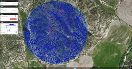
Monitoring of vineyards with mapp.it has become simultaneously more efficient and more interactive through the combined use of high-resolution drone imagery for accurate spatial reference data and data from the Sentinel-2 satellites of the European Union's Copernicus programme, for corrected 5-day updates on vine vigour.
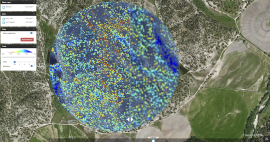
A similar, combined drone-satellite application has been demonstrated for monitoring disease progression in the protected cork oak forests, where the only option for disease detection is the felling of selected trees.
Launched on 23 June 2015 and 7 March 2017 respectively, Sentinel-2A and -2B carry an innovative wide swath high-resolution multispectral imager with 13 spectral bands, for a new perspective of our land and vegetation.
Since both Copernicus Sentinel-2 satellites image the surface of Earth with a 290 km-wide swath, most of our planet can be covered every five days. This means that it is an ideal mission to use for generating background reference maps that are not only consistent, but that can also be updated frequently.
João Araújo, Chief Operations Officer at Spin.Works, comments, "Copernicus Sentinel-2 data enable the best of both worlds: high temporal and spatial resolution by combining 5-day satellite data with 5cm drone data through our algorithms."
About the Copernicus Sentinels
The Copernicus Sentinels are a fleet of dedicated EU-owned satellites, designed to deliver the wealth of data and imagery that are central to the European Union's Copernicus environmental programme.
The European Commission leads and coordinates this programme, to improve the management of the environment, safeguarding lives every day. ESA is in charge of the space component, responsible for developing the family of Copernicus Sentinel satellites on behalf of the European Union and ensuring the flow of data for the Copernicus services, while the operations of the Copernicus Sentinels have been entrusted to ESA and EUMETSAT.