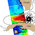
This year's Atlantic hurricane season has been a harsh reminder of the grief and devastation brought by these vast storms. Imaging the top of hurricanes from space is nothing new, but the Sentinel-1 satellites can see right through these towering spinning weather systems, measuring the sea surface below to help predict the storm's path.
The 2017 hurricane season isn't even over yet, but 10 Atlantic storms in a row have already reached hurricane strength – the first time this has happened in more than a century.
Since understanding and predicting these powerful weather systems is essential to saving lives and property, scientists have been looking into how the Copernicus Sentinel-1 radar mission can help.
