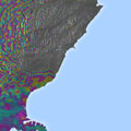
Satellite radar scans of last year's earthquake in New Zealand are changing the way we are thinking about earthquake hazards in regions where our planet's tectonic plates meet.
Satellite radar scans of last year's earthquake in New Zealand are changing the way we are thinking about earthquake hazards in regions where our planet's tectonic plates meet.
The 7.8-magnitude quake that struck New Zealand's South Island near the town of Kaikoura on 14 November was one of the most comprehensively recorded earthquakes in history.
Immediately after it, a team of scientists from New Zealand, the UK and the US began to study radar images from the Copernicus Sentinel-1 and Japanese ALOS-2 missions to measure the extent of the land movement.
