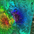
New information on the effects of the 30 October earthquake that struck central Italy continues to emerge as scientists analyse radar scans from satellites.
Using radar imagery from the Copernicus Sentinel-1 satellites, Italian experts have identified significant east–west displacements of the ground in the area struck by the earthquake.
An eastwards shift of about 40 cm was mapped in the vicinity of Montegallo, while a westwards shift of about 30 cm is centred in the area of Norcia.
Vertical displacement is also evident, with the ground sinking 60 cm around Castelluccio but rising by about 12 cm around Norcia.
The team of scientists from the Institute for Electromagnetic Sensing of the Environment of the National Research Council and the National Institute of Geophysics and Volcanology combined radar scans taken before and after the event to map centimetre-scale changes.
The team has benefited from the two Sentinel-1 satellites of Europe's Copernicus programme. While Copernicus is led by the European Commission, ESA is in charge of developing the satellites and operates Sentinel-1.
