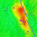
On 24 August, an earthquake struck central Italy, claiming at least 290 lives and causing widespread damage. Satellite images are being used to help emergency aid organisations, while scientists have begun to analyse ground movement.
The Italian peninsula is prone to earthquakes because of the continuing collision of the African and Eurasian tectonic plates. Under the Apennine mountain chain, the regional collision is causing the African slab to flex and dip under the Tyrrhenian Sea, while at the same time retreating northeastwards. The slab's retreat is the main process driving the present tectonic extension which causes earthquakes like this one and the 2009 quake that devastated L'Aquila.
Under the coordination of the Italian Department of Civil Protection, scientists from Italy's National Institute for Geophysics and Volcanology and the Institute for Electromagnetic Sensing of the Environment of the National Research Council are studying data from the Sentinel-1 satellite mission and other spaceborne radar missions to map surface deformations caused by the earthquake.
The team found that the main deformation pattern shows subsidence reaching about 20 cm in the Accumoli area, and sideways movement of up to 16 cm.
