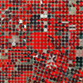
From agricultural monitoring to charting changing lands, early images from Europe's new Sentinel-2A satellite show how the 'colour vision' mission's critical observations can be used to keep us and our planet safe.
From agricultural monitoring to charting changing lands, early images from Europe's new Sentinel-2A satellite show how the 'colour vision' mission's critical observations can be used to keep us and our planet safe.
Launched from Europe's Spaceport in French Guiana on 23 June, Sentinel-2A is the second satellite in orbit for Europe's Copernicus environmental monitoring programme.
Its multispectral camera will feed land-monitoring applications such as agriculture, inland and coastal waters, and land-cover mapping.
At an event in Milan today, experts who had been given access to early Sentinel-2A images discussed how a variety of operational and scientific applications will benefit.
"European citizens, decision-makers, enterprises and the international scientific community will greatly benefit from this second mission for Copernicus. Its imagery enables us to improve the quality of life of our citizens and protect our environment," said Mauro Facchini, Head of the Copernicus Unit at the European Commission.
