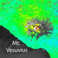
With frequent observations from the year-old Sentinel-1A radar satellite scientists are improving the remote sensing technique to map ground deformation, opening new doors for earthquake and volcano monitoring.
With frequent observations from the year-old Sentinel-1A radar satellite scientists are improving the remote sensing technique to map ground deformation, opening new doors for earthquake and volcano monitoring.
By comparing data from past satellite radar missions - ERS and Envisat - with those obtained from the current Sentinel-1A, researchers of Italy's Institute for Electromagnetic Sensing of the Environment (IREA-CNR) have shown the drastic improvement in mapping surface deformation.
To achieve this, the scientists used the Interferometric Synthetic Aperture Radar, or InSAR, technique. This involves combining two or more radar images acquired at different times. If something on the ground has changed between the acquisitions, the terrain deformation is displayed as a continuous sequence of coloured stripes called interference fringes, or an 'interferogram'.
