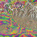
On 25 April, a 7.8-magnitude earthquake struck Nepal, claiming over 5000 lives and affecting millions of people. Satellite images are being used to support emergency aid organisations, while geo-scientists are using satellite measurements to analyse the effects of the earthquake on the land.
Radar imagery from the Sentinel-1A satellite shows that the maximum land deformation is only 17 km from Nepal's capital, Kathmandu, which explains the extremely high damage experienced in this area.
By combining Sentinel-1A imagery acquired before and after the quake, changes on the ground that occurred between the two acquisition dates lead to rainbow-coloured interference patterns in the combined image, known as an 'interferogram', enabling scientists to quantify the ground movement.
Sentinel-1A's swath width of 250 km over land surfaces has allowed for an unprecedented area size to be analysed from a single scan. The entire area will be covered under the same geometry every 12 days, allowing for the wider region to be regularly monitored and fully analysed for land deformation with the powerful 'interferometry' technique.
