Radar images from the Sentinel-1A satellite are helping to monitor ground movements of the recently erupted Fogo volcano.
Radar images from the Sentinel-1A satellite are helping to monitor ground movements of the recently erupted Fogo volcano.
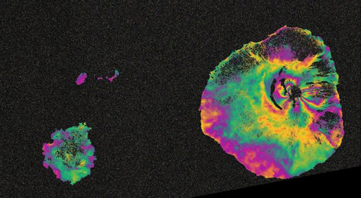
The image below - an 'interferogram' - is a combination of two radar images from 03 November and 27 November, before and during the eruption.
Deformation on the ground causes changes in radar signals that appear as the rainbow-coloured patterns.
Scientists can use the deformation patterns to understand the subsurface pathways of molten rock moving towards the surface. In this case, the radar shows that the magma travelled along a crack at least 1 km wide.

