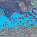
Although not yet operational, the new Sentinel-1A satellite has provided radar data for mapping the floods in Bosnia and Herzegovina.
Although not yet operational, the new Sentinel-1A satellite has provided radar data for mapping the floods in Bosnia and Herzegovina.
Heavy rainfall leading to widespread flooding and landslides has hit large parts of the Balkans, killing dozens of people and leaving hundreds of thousands displaced.
Jan Kucera of the European Commission's Joint Research Centre is supervising the technical aspect of the Copernicus Emergency Management Service (EMS). While mapping the flooding in northeastern Bosnia and Herzegovina, ESA delivered a radar scan from Sentinel-1A: "I had a first look and discovered that we were missing an important flooded area visible in the middle of the image."
Although the radar on Sentinel-1A is still being calibrated, the new information could be integrated into the Copernicus EMS flood maps of the Sava river in the Balatun area in Bosnia and Herzegovina.
