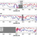
Coastal Satellite Altimetry data, including those from ESA's Envisat mission, have not been fully exploited yet, because the sea level estimation in coastal areas is considered unreliable.
Coastal Satellite Altimetry data, including those from ESA's Envisat mission, have not been fully exploited yet, because the sea level estimation in coastal areas is considered unreliable.
In order to extract the sea level signal from the received radar echoes (waveforms), a model response is fitted to the real waveform in the retracking process. Waveforms collected in the coastal areas present variable shapes that differ from the typical open ocean model. It has been found that this difference is due not only to land interference, but also to patches of calm water within the footprint of the altimeter.
To overtake the problem, an innovative retracker has been designed and validated: ALES (Adaptive Leading Edge Subwaveform Retracker) selects only a part of the waveform in order to avoid the interferences. The width of the selected window is adapted to the sea state to guarantee the same theoretical precision of sea level estimation. The method has been tested for Envisat and Jason 1/2 missions, but it is potentially extendable to the other radar altimeters.
