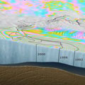
Twenty years of radar coverage from ESA satellites have been used to measure the rapid thinning of Antarctica's Pine Island Glacier - and it's losing more ice than previously thought.
Twenty years of radar coverage from ESA satellites have been used to measure the rapid thinning of Antarctica's Pine Island Glacier - and it's losing more ice than previously thought.
Pine Island is the largest glacier in the West Antarctic Ice Sheet and one of the fastest ice streams on the continent. About a tenth of the ice sheet drains out to the sea by way of this glacier.
At the margins of ice sheets, ice lifts off of the land and floats out over the water as an ice shelf. Measuring these ice shelves and following their evolution is important for pinpointing the mass of an ice sheet and its contribution to changing sea levels.
But measuring them is difficult. Drilling and submarine surveys can be performed locally, but do not provide the continuous and global measurements needed for accurate monitoring.
Satellites can gather information frequently and over large areas, providing an effective means to quantify the melting of ice shelves. Radars on satellites can 'see' through clouds and in the dark, making them particularly suited for measurements over polar regions prone to bad weather and long periods of darkness.
